30 Unusual Maps That Might Change How You See The World, As Shared In This Online Group (New Pics)
InterviewThe map might not be the territory, but gosh darn it both aren't fascinating to look at! We’re pretty big fans of maps and we can’t wait to set our eyes on even more unusual and peculiar ones in order to expand our minds and feed our imaginations which are hungry for aesthetic designs. Luckily for us, there are tons of like-minded internet users who are nearly bursting with their love of maps.
This subreddit about maps has nearly 1.5 million members and probably has more creativity than I’ve personally seen anywhere else on Reddit so far. Even though we can’t mention the subreddit’s full name because we'll get censored, the community is truly friendly and has stood the test of time since May 2011. And the person to thank is land surveyor Patrick McGranaghan, the founder of the entire project, whose passion for maps is beyond measure and keeps the online group together.
Patrick and I had a wholesome chat about how to get ourselves moving outside our comfort zones and on adventures, what maps he's recently been working on, as well as the ins and outs of moderating the subreddit.
"I've noticed, especially as I've gotten older, that you only have so much time on this planet and every day that is wasted is a day that you'll never get back. If you want to get out and explore the world you just have to do it. Some adventures will cost time and resources, but the real question I ask myself is can I afford not to do some goal I have my heart set on. There are so many opportunities in this world that it may be hard to choose, but if you wait too long those opportunities will be gone forever," he told Bored Panda to seize the day and really start living.
Bored Panda has featured the subreddit extensively in our previous articles. When you’re done upvoting and commenting on your fave maps in this list, keep in mind that there’s a whole land of adventure waiting for you in these earlier posts right here: Part 1, Part 2, Part 3, and Part 4.
More info: Reddit | Twitter | Tumblr
This post may include affiliate links.
This Is A LEGO World Map I Designed! I Spent Many Hours Staring At Google Earth And Topological Maps To Make This
I saw one not long time ago, but this one look much better! The one made by Lego is too plate for my taste : https://www.journaldugeek.com/2021/06/02/lego-devoile-une-carte-du-monde-de-11-695-briques/
Load More Replies...They should put this on Lego Ideas if it isn’t already. Kits that get 10,000 votes are considered for production, and many have been. Including the Saturn V rocket, Ghostbusters car, and several of the modular buildings.
Map Of Africa's Borders If Divided By Languages and Ethnicities
One of the terrible harms of colonialism was in drawing borders that utterly disregarded these connections among people and created terrible unnecessary conflict. (Just like Catalonia in Spain, etc. but on a much greater scale.)
I was thinking instantly of Afghanistan, actually. Convenient on a map, absolute BS on the ground.
Load More Replies...This concept of "borders" misrepresents reality. Many of them should overlap. The concept of "my land ends here and your land starts there" doesn't work with nomadic cultures. Often different peoples share the same land, yet might not see each other since they use it at different times of the year.
That's another problem with sharp borders - that they have no way of respecting cultural intermingling - like Zulu people being divided across South Africa and Zimbabwe, but also living amongst Shona people and other groups in both countries. But regarding nomadic groups - I don't think there are many nomadic sub-Saharan peoples. The Khoi-San in South Africa and up into parts of Namibia were nomadic, but they'd been driven back into a fairly small area even before colonialism - not that colonialism didn't hugely worsen their situation.
Load More Replies...I'm Nigerian, and we have over 250 languages the dominant ones being Yoruba (mine), Igbo and Hausa. I believe that the only advantage of colonialism is the English Language. English is our official language and I accept that, as it would be quite difficult to choose one from so many languages. Also, English eliminates the difficulty of communication with other languages. But British colonialism is shitty and most of us hate y'all for this. Thank you
Nigerian here. What part of Nigeria are you from?
Load More Replies...Africa's real borders are so geometric that they freak me out for some reason.
If anyone knows where to find a high-res version of this map I'd appreciate a link!
Hello! I Was Told You Would Enjoy This- Took Me 3 Years!
No point trying to talk to the person who posted it as they posted it on Reddit. Not this site.
Load More Replies...It was probably not yet discovered at that time: parts of North America are also missing.
Load More Replies...Just not sure why China and India are designated and marked just like the continents, but to be honest, I couldn't stitch even the names of countries. Great job.
Probably because they were marked like that in the historic model for this stitching, too.
Load More Replies...I was interested to hear about Patrick's recent cartography projects as well. He told me that recently he's been focusing on pixel maps which are bound to get some of you Pandas nostalgic. "This spring, I was making a lot of pixel maps that looked like old video game graphics. I picked some exotic places like Botswana and Mongolia to make these maps," he shared with Bored Panda.
"I think a great way to learn about an exotic place is to make a map of it and really give some hours and care into making the map look as good as possible. You really get a connection for a place as you're putting labels on and making decisions about what to include and where to lay everything out."
World Map Of Borders
they systematically forget France-Brazil, and France-Holland. is this a sect x)
Greenland is not a country, it's an island belonging to Denmark. the same with Faroe islans for example.
Load More Replies...Sorry. It's there but uncoloured and very badly drawn. It's also in the wrong place.
Load More Replies...Gives an interesting insight into Covid management strategies of different countries
Hello! I Cross Stitch Earth Science Maps And Have Been Told They Belong Here. Great Lakes Bathymetry Is My Favorite So Far
yes! This piece sold but I have others, and I sell cross stitch patterns and kits for these as well www.etsy.com/shop/BlondeBoxshell
Load More Replies...How A Coastline 100 Million Years Ago Influences Modern Election Results In Alabama
Now I want to know what caused the sediments to be laid down in this pattern to start with. We need to go back further.
It was a coastline, so presumably lots of fossils laid down (by tidal flow) which led to more agriculture millions of years later.
Load More Replies...This is the sort of thing that I find very interesting about studying geography - just how completely arbitrary details define the different lifestyles and practices and the absurdity of geopolitical borders. These people just 10 miles away speak another language and worship another god and die younger and can't get enough to eat and aren't permitted basic human rights and also we hate them. Why? Well mostly because there's a river here between us.
Without keys it’s difficult to understand. So I gather that those living with more fertile soil voted Democratic in the last election?
There's a description if you follow the link, but you got the gist of it. Fertile soil meant bigger farms, which meant more enslaved people, which meant more black people even in modern times, which meant more Democratic votes.
Load More Replies...This has me wanting to sit down and really research the details.
Well, the belt seen was very likely good ground for large scale plantations with a big slave population. In the end it's in the economics of stuff.
That's depressing as hell. Let's move the coastline and get rid of the racists lol
Alabama has the most Republican white vote of any state in the US. Trump in 2016 and 2020 won over 90 percent of the white vote in the state, and in 1968 and 1972 Democrats did even worse. Before 1968, of course blacks did not vote in significant numbers in the state. Alabama, indeed, had the most violent civil rights movement of any state. In his 2015 book ‘Paths out of Dixie’, Robert Mickey compares South Carolina, Mississippi and Georgia, but said he did not discuss Alabama because of its “much earlier industrialisation”. As I see it, Alabama’s earlier industrialisation made civil rights more difficult because the ruling class had more incentive to resist and more belief that it could completely defeat the civil rights movement. That is why its state party moved away from the national party so early and took even longer than Mississippi to reconcile.
As for moderating the subreddit, which continues growing, it's always been about finding the right balance. Patrick also told me that moderating things, just like doing anything in life, means that there will always be someone who's unhappy with your decisions.
"Moderating is always a delicate balance. It is impossible to please everybody. If you are too laissez-faire you get a lot of low effort and ugly submissions and the users complain. If you are too strict, then you risk alienating those who supply the content for the sub. I try to find a balance between these two extremes. Overall, I'm satisfied with the moderating and I don't foresee any changes in the immediate future," he said.
As for the future? Patrick's finally traveling to Europe again and plans to have a grand old time in Italy soon.
I Am Working On A Picture Book With Each State Drawn With One Line. I Finished My 7th State Last Night
Does anyone else find it easier to read the word whilst actively scrolling?
I’m guessing the ‘map’ part comes from it being shaped like Colorado, I’m willing to bet that the first 6 were also shaped like their respective states and not just rectangles.
It could be considered a piece of a map. It's 7th state done, and shaped like Colorado.
Load More Replies...I'm from Colorado and I knew that's what it was before I realized it said it at the bottom 🤣❤️
Hand Drawn Map Of China And Neighboring Countries With Placenames In Mandarin (I Drew It As An Exercise To Memorise All The Provinces)
And I might ask why such a beautiful piece of art is still in a spiral notebook rather than framed and proudly displayed? Hint hint....
No point trying to talk to the person who posted this. They won't see it. They posted it on Reddit months ago.
Load More Replies...Antarctica Without Ice, U Don't See That A Lot
Don't worry, we are working on it. Come back in a couple millennium.
I think the land would rise up a bit with all that weight removed. So this probably isn't completely accurate.
Yep, isostatic rebound. It's still happening to the crust in the Northern Hemispere from the last glacial period. The Hudson Bay region of Canada is rebounding at an astounding rate of over 1.25cm per year.
Load More Replies...It’s the geographic South Pole. There would of course be massive static rebound without ice, totalling probably about 1,000 metres
Load More Replies...How do we actually know this? Ground-penetrating radar? Some kind of infrared radiation or something?
this is very interesting. the land formations look very different. it took me a minute. but there are no rivers. the bodies of water don't join up and flow out like they would if there was rain and freeze/thaw cycle that led to run-off. that is really neat.
That’s true. It is not certain where the rivers would flow to the sea, but they certainly would flow through large open lakes as they do in Canada today.
Load More Replies...Previously, I had a couple of in-depth chats with Patrick, the founder of the subreddit, about the project, learning to navigate better, and the state of travel during the pandemic. In the decade since its founding, the subreddit has blossomed into a welcoming niche for cartographers—professional and amateur alike—all over the globe. Everyone’s welcome, so long as they stick to the rules and stay polite. Patrick developed his love for maps very early in his childhood as his family traveled and moved a lot.
"The older I get, the more I realize that spatial awareness just comes naturally to some people, and for others, it's a struggle," Patrick pointed out to Bored Panda that just like with any other skill, getting good at navigating requires patience, dedication, and repetition.
“In a way, reliance on Google Maps has made us dumber. We let the navigation app do all the work for us and don't engage with making the decisions," he said.
Are You Closer To Georgia, Or To Georgia?
Fun fact: the pronunsiation of Georgia (that which is not in USA) for Russian speakers is [gruzija], like if it's name Groozija (Грузия), and not Georgia ['ʤɔːʤɪə].
In Denmark it is Georgia for the state and Georgien for the country. No confusion.
I am not proud to say that I lived in Georgia for 2 years. But I sure would be proud to say I lived in Georgia for 2 years.
Mythical Beasts Of The United States Of America
The Fouke Monster is definitely more well known in Arkansas than any "Ozark Howler". Maybe that's a Missouri thing.
I was thinking the same thing. There's even a 'bigfoot' cafe not far from me.
Load More Replies...Considering how many episodes of Finding Bigfoot there are I really expected that chap to show up in more locations on the map.
Yes! They are always hunting him in Ohio. And with the amount of actual hunters and outdoor activities people do I can tell you he isn't here!
Load More Replies...Interesting to see the "Bear Lake Monster" sitting above Utah but not "Old Salty" in the Great Salt Lake.
The Topography Of The Roman Empire, Ad 117
If you zoom it enough, you can see a little pixel without colour.
Load More Replies...Well when it comes to democracy and literature (except for Ovid) it’s mostly Ancient Greece that is the good old days.
Load More Replies...When people believes that latin stands for latin american only, show them this map.
They would have no idea what they're looking at LOL
Load More Replies...Scotland has Roman forts near Elgin and a second wall between Glasgow and Edinburgh. It's just that Hadrian's wall is a fallback position protecting mineral resources.
Load More Replies..."If you live in a place with a tall hill or some viewpoint, go up there some time and look around. Try to identify as many landmarks as you can. Notice where they are in relation to each other. Look for new landmarks that you've never noticed before and keep them in mind as you navigate your hometown. If there are rivers or other features that cause chokepoints on bridges or highways, memorize all the bridges and where they go. In this way, you'll know the layout of your city and how to get around," the subreddit’s founder, Patrick, gave us some pointers on how to up our navigation game.
With mass vaccination programs continuing to gather steam, global travel and adventure are nonetheless still in a very confusing situation right now. On the one hand, lockdowns had ended in some countries (and in the case of the United Kingdom will end on ‘Freedom Day’ on July 19, though with some confusion over mask-wearing going forth).
However, the quick rise in new cases after ending restrictions (e.g. in the Netherlands where cases soared by a whopping 500%), along with the continued spread of the Delta variant of Covid-19, mean that these same regulations are returning. And the rules keep changing very quickly, so it’s a nightmare to follow if you’re traveling, even if you’re double-vaxxed and immune.
Average Number Of Languages Spoken By The EU Population
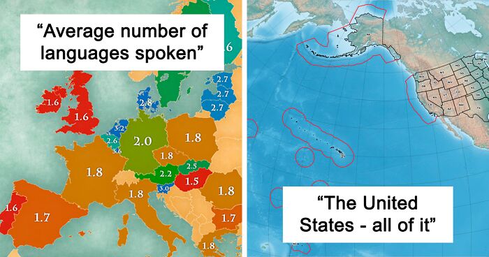
The extra 0.6 in the UK is definitely from immigrant families and their descendants, plus those Brits that continue to use Welsh/Gaelic/Irish after school. The average indigenous Brit doesn't speak more than English with anything approaching fluency.
In that case Germany should be at least 2.5 We have a lot of immigrants and lots of people speak very good English here. So it's German, English and whatever other language for us..... and some even learn up to 3 languages at school
Load More Replies...Luxembourg : 3.6 - The two official languages of the country are German and French. School is the first 6 years in German - the other 6 in French. Next to that everybody speaks Luxembourgish and English. With a huge portugese population, this is the only country I know where you start a conversation with : "which language"??
Language is a "use it or lose it" sort of thing. I learned French in school, but with nobody to practice with, the skill just disappeared after a while.
Totally cool. I have such respect for people who can speak more than one language.
Hahaha Finnish people do not like to speak Swedish atleast, sure they may be good at English but Swedish they seem to hate xD
It's because what we learn isn't the real swedish, it's the mangeleg finnish-swedish the real swedes have a hard time desiphering, so english it is.
Load More Replies...This can´t be right. I´m portuguese and people here learn french and english in school....
Learning it at school doesn't necessarily mean you speak it. I guess the definition of what speaking it means is missing here.
Load More Replies...Funny 2.6 in Belgium? The place where people gets offended and yells at you if you dont speak flemish or french? Where the south and north cannot talk because they cant understand each other? A lot of people lied in that survey
I am Belgian. Learned Dutch, French, English and German at school. Learned Spanish in Spain. I never yell at anybody when they don't speak French or Dutch (btw, Flemish is not a language, in Flanders we use the same dictionaries as they do in The Netherlands). Please do not believe everything you read in newspapers. Politics ...
Load More Replies...How To Read A Topographical Map
In the absence of any indicators of altitude or depth on those contours, each of those could be holes instead of mountains. The assumption in this graphic is that these are mountains and that each successive contour line is a height and not a depth.
Turn the image around 180 degrees, Captain Obvious.
Load More Replies...I Drew A Map Of All Japanese Prefectures (Took 6 Hours). Hope You Like It
And you're trying to speak to someone on Reddit from 3 months ago.
Load More Replies...These hand-drawn maps are just delighting every instinct of appreciation I can muster. Reminds me of years ago in school (drawing as assignments) and sadly, that with the evolution of technology and automation, it's a talent likely to fade quickly.
“I think we all have to take precautions, get vaccinated, and avoid risky behaviors. That said, I think we need to remember that we're fighting to eradicate this disease and get back to a normal state of affairs. I really miss the freedom of travel. We're losing years of potential happiness to the lockdowns and at some point, we need to open up. Those are issues above my pay grade though and I hope it's sooner rather than later," Patrick told me in late spring.
According to Patrick, who makes maps for a living, he’s heard tons of people say that everything has already been mapped. However, he points out that there will always be a need for new maps as time goes by.
"People say, 'Hasn't everything been mapped?' The world is constantly changing and accurate spatial data is a fleeting thing. Google Maps certainly gives the impression that everything is mapped, but there is selection and generalization in their data," he said.
This Is My Friends Wood Shop Project, Thought It Would Be Fitting Here
Here in Ireland there is a company that makes a jigsaw puzzle of the map of Ireland with the pieces being the different counties of Ireland. Each piece has the county's name on it and when all the pieces are put together you get the full map of Ireland with all the counties in the right place. It is used as a way to teach young children the counties of Ireland through play.
It's how I learned all the states over here as a child. Puzzles are awesome.
Load More Replies...Don't know if this is the same one or a different one, but I recall someone did the same thing but each piece of wood is from that particular state.
Her name is Xyla Foxlin. " Foxlin drove across the country — from Cleveland, Ohio, to Los Angeles, California — visiting a sawmill in every state she visited and making a map of the local wood she collected on her way. She posted pictures of her experience, and the map, on Reddit and answered questions from Redditors about the trip. She also released a YouTube video documenting her travels and highlights from her road trip."
Load More Replies...Years ago I saw one made with stones and minerals from each state.
My mom collected those tacky State magnets every time she went somewhere. I inherited the magnets and I love them now of course . This beautiful post reminds me of my mom so thanks for the smile
If US Land Were Divided Like US Wealth
Historically this never ends well. As the gap between have and have nots grows, instability increases. I think we are seeing that now. Are we close to chanting PITCHFORKS! What do you think?
Load More Replies..."Socialism, the social and economic doctrine that calls for public rather than private ownership or control of property and natural resources."
Load More Replies...It seems pointless bringing this up over and over and over and over again.... Not enough of America wants to address this, so it wont be addressed. Just like healthcare, gun control, education etc. The people that believe in trickle-down economics are also those that believe they have a chance to be part of the 1%, believe that vaccines cause autism, the earth is flat, the moon landing was faked, that there is a invisible man in the sky etc... Its a lost cause. We have the same thing in Aus (minus the gun control issues - and our wealth distribution disparity isn't as huge - but is still significant ) - with approx 50% of the population supporting their own - and everyone else's demises - all so they can keep their heads buried in the sand.
Pointless to bring more attention to these problems? Silence will not help, we need to nag. Publish, produce films, PSA's, protests, bumper stickers -- ANYTHING to keep the important issues in front of people. Do not let people forget.
Load More Replies...In the US there is very little old money wealth. So this is a bit of class hyperbole.
This is important to view with intelligence, rather than simply crayon instincts: NEARLY all of this can be explained by three factors. 1. Rate of savings for retirement. 2. Age. (Length of savings period). 3. Savings portfolio composition. The average income earner, having saved 15% of their savings, from 1960-2000, then lived off their S&P 500 index fund dividends since 2001, will be in their 80s, and in the top 1% of wealth. The average 70(s) year old will have had to match that via a 20% savings rate, and had 10% above the national average income, and had 90% in the S&P 500, 10% in NASDAQ, and benefitted from housing rules/real estate. To be in the 1% at 40, you have to employ about 120 people, and own more than 40% of your equity. .... As it is, 50% of the population are below 34 years old and have just started a family, and/or are clearing their student loans/mortgages... 25% are school age or younger... How much of the US should they own? Lols, none, right? Exactly. ;)
But don’t raise the taxes of those top 10% . That would be unfair. 🤬
The United States — All Of It
Samoans get screwed the worst. Huge population born in American Territory (just like Guam and Puerto Rico), but not given citizenship. (Guam, PR get it.)
They aren't screwed. They get nearly all the benefits of being a citizen, but keep their indigenous status, which gives them more benefits, and have their own separate government, also giving them other benefits. The only thing that Nationals, but not citizens, as Us citizens are also nationals of the US, have that is different is that the U.S. Samoan and Swain Islander nationals are not allowed to vote in federal elections, serve in the US military, or serve in a federal office. This is because they have their own government, and are thought to not be able to be completely loyal to two different ones at the same time. I'm not sure how this is screwing them. Besides, it isn't very difficult for a Samoan, or Swain Islander to become a citizen should they want to.
Load More Replies...It's missing Navassa Island off the coast of Haiti. This uninhabited island was claimed by the US in 1857 for its guano. Mining took place between 1865 and 1898. The lighthouse, built in 1917, was shut down in 1996 and administration of Navassa Island transferred from the US Coast Guard to the Department of the Interior, Office of Insular Affairs. A 1998 scientific expedition to the island described it as a "unique preserve of Caribbean biodiversity." The following year it became a National Wildlife Refuge and annual scientific expeditions have continued. As listed in its 1987 constitution, Haiti maintains its own claim to the island. LOL! https://www.cia.gov/the-world-factbook/countries/navassa-island/
"Infrastructure is a key thing that we all rely on and don't realize it. The electricity to turn on your lights, the fiber that carries this message, the water that you drink. All those things are traveling to you above and below ground. Construction is constantly happening along this route. Knowing where to safely build is critical,” Patrick told Bored Panda about the need to map and remap the world that surrounds us.
"There are other themes that have spatial data too. Municipalities pass zoning and other restrictions all the time. Cities like London have an umbrella of rules about the preservation of old buildings, view-lines, noise nuisances, and other regulations. Making accurate maps is a constant struggle that is going to stay with us for a long time. As more things get built, knowing where these are located is important. Maintaining the world's databases of spatial information is the task of the modern map-maker." There will always be a need for maps and, we hope, for the entire subreddit as well.
What Are Your Thoughts On This Breggsit?
My Son’s (12) Map Of The Balkans
Speaking as a guy from the region, great job (My country's name has a tiny spelling error, but let's not make a fuss about it :-) ).
Even though I'm sort of a map nerd, I still don't have this region clear in my head since the breakup of Yugoslavia.
There is only one problem with this picture. This is not the Balkans. While this kid could copy a map he is clearly lacking of geography.
Yes it is, what are you on about? although Italy, and a handful of other countries are shown, 80% of it is!
Load More Replies...Well...kinda both, still. Many Czechs really hate the word "Czechia" (me included).
Load More Replies...Once again... I miss the days that hand-drawn maps were the normal learning tool in school.
Ooh that reminds me of this map I made a few years ago when I was around 10-11 https://docs.google.com/file/d/18eMkZy0bUXIkgurbLArYVLLMQf4xJ-2n/edit?usp=docslist_api&filetype=msword I’m a total geography nerd lol
Rural Equivalent Of New York City, Los Angeles And Chicago
Okay. This is impressive. Very impressive. Haven't thought it would be so... well... impressive.
Yes. But the important question is...were you impressed?
Load More Replies...Lol, it's actually the exact reason we have an electoral college.
Load More Replies...i went to NY in 2014, it's impressive the amount of people walking in the sidewalks the whole time...
LA County is more than the city of LA which is 3.9 million people, 10 million is the LA Metropolitan area. and Chicago only has 2.71 million, not 9.53, 9.53 is the entire metropolitan area. If you took the whole NYC Metro area like you did with these two other cities it would be 20.3 Million people. That 8.5 is just the city itself.
This map shows that without the Electoral College politicians running for president can concentrate their campaigns only in high density population areas to win an election.
I don't know, this is kind of why its crap. Why ignore so many people just because they're packed into a smaller place?
Load More Replies...This is unexpectedly intriguing. Now I want to know how all the other "big" cities stack up too.
Children’s Map Of The World (Only Shows Countries Where Smacking Children Is Illegal)
I don't know what map you're looking it but it is 100% illegal to smack a child in a LOT of the USA.
But not in all of USA. Therefore, it's allowed in USA and it can't be there. The same happens with other countries.
Load More Replies...Smacking is allowed in Australia as long as it is 'reasonable in the circumstances'.
Load More Replies...The Great Lakes And Saint Lawrence River Superimposed On A Map Of Europe
I live on the shore of one of the smaller ones and I can't see the coast on the other side.
Load More Replies...I live in Michigan and people who have never seen the Great Lakes are always surprised at how big they are. Superior might as well be called a fresh water inland sea.
I used to live in Michigan and I kept telling my European friends the Great Lake area is like a sea with five bodies of water!
Load More Replies...I’ve seen 3/5 of the Great Lakes and hope to see the other 2. Growing up on Lake Michigan makes me appreciate their beauty and power.
Me too! I'm in the Cleveland area so obviously Erie a lot and have been to Lakes Michigan and Ontario. Hope to see the other 2 one day! Also I have never had Dippin Dots and it is my life goal not to! They have them all over the zoos so it's a running joke with my husband.
Load More Replies...Why Is [country]...? - Google Autocomplete Results (European Countires, 2021)
Many Polish people think Slovakians are much richer than us
Load More Replies...well I just did this search for Germany, from Germany, and got "Why is Germany so boring"... I wonder why so many people seem to think the country is boring
..."called Romania" ... a sarcastic title ... but at least I'm proud that no other stereotype has been assigned
Actually, i think the reason for this question is how the name of the country is related with the Romans; do a search after "why is called Romania" and the first info is: "The name "Romania" comes from the Latin word "Romanus" which means "citizen of the Roman Empire." ... The people who inhabited the area of modern Romania were called "Getae" (Geti) by the Greeks, and Dacians (Daci) by the Romans."
Load More Replies...Because the men's team sucks. The women's however is the best in the world forever and always! Go Pinoe! Go Tobin! Yeah Abbbbbbbbyyyyyy!
Load More Replies...It is to Mediterranean people because we are weather spoiled and we aren't used to England kind of rain. However, it's very good weather compared with most places in the world: there aren't extreme temperatures, not floods, not tornados, not dry and wet seasons, etc.
Load More Replies...Well, if they ask it may mean that people (English speakers?) are surprised that Ireland isn't as poor as they thought. 🤷♀️
Load More Replies...I Made A Gingerbread Eastern Hemisphere!
Since the Earth is a globe, you can put the East wherever except the poles.
Load More Replies...How fun. And not so easy without being 100% certain where and how much the dough would shrink and expand during cooking.
Age At First Marriage
The U.S. data doesn't quite fit that observation
Load More Replies...The countries that display as <20 are probably those with a lot of child marriages. It's a bit misleading because only one half of the couple is usually the child.
I bet this map changes over time... wonder what it looked like in 1930? 1960? 2000?
and with the genre, I bet their are very diferent, more and more if we go back
Load More Replies...Well I guess my parents got married a little early.
Africa, 10 Million Years Later. (Based On Current Predictions And Data)
The Rift is actually the border between two tectonic plaques, as its name say;)
Load More Replies...And people were worried about California splitting off from the rest of the US....pfffft
Why freak out? Firstly, we will all be dead in a 100 years. Secondly, we can't predict what weather we'll have the next Tuesday. What makes you think there is any truth in a prediction for ten million years?
Load More Replies...It's going to be a lot shorter than 10 million years. It's already cracking apart now.
The Most Culturally Chauvinistic Europeans
Especially since "Chauvinism" is a french term XD
Load More Replies...There is no way the UK is less culturally chauvinistic than Norway. Have you never heard a Brit speak?
A huge number of us are ashamed of our country.
Load More Replies...Hahahahah Fance 36% and they put 50% on Switzerland!!! Do this guy have one time in his life met a French?
I agree, there's something wrong in France's data, but nevertheless swiss percentage could be superior to France's: have you ever met a Swiss in your life?
Load More Replies...This seems to be a case where I would want to see questions and sample size because it is not what I experience. Russians routinely used to apologize to me for how "terrible" Russia must be compared to the US. I had to actually tell some of them to stop it.
Sweden is suspiciously low - in Scandinavia they're known for being smugly superior (even though they're clearly the worst one) ;)
Finland is good at everything so they deserve to be rated high I think. :)
Load More Replies...F**k, I'm greek and regarding greece this map is spot on. Having lived a decade in the UK and travelled throughout Europe extensively, I dare say some of the other countries score look suspect
Greek here too! Our score is definitely accurate but didn't expect to have such big difference with the rest! I mean the second highest is 20% lower than our score!
Load More Replies...A lot of the most chauvinistic countries are not very successful. Greece has suffered extremely from a financial crises a few years back. They are not only unsuccessful, they have also lost a lot of their wealth. Make people poorer = increase racism, If there is anything that simpleminded politicians need to hear it's that simple equation. Especially liberal politicians who wants to decrease wages, take actions that increase rent, lower pensions or increase taxes on poor people. Don't do it you dumb asses, it's not worth it.
It has nothing to do with success though!I'll speak for my country Greece... We know we have financial issues that we are never going to solve, however being one of the most ancient civilisations on earth has made us feel superior! I don't justify it I'm just saying that Greeks' beliefs in superiority have nothing to do with the present! It's the past they are referring to! Many people feel that the world still owes us a lot! However the last time we were successful was hundred thousand years ago 🙄
Load More Replies...I think they accidentally swapped Greece and France. France is just notorious for hating everyone else.
What Does A Horse Say In Your Language?
I'm pretty sure that German horses do something more like "wieher" or "hüüüah" I don't even know what Ii-haha is supposed to ressemble... that's closer to a donkey.
100% agree. In German we say 'hü' for horses, and 'i-ah' for donkeys.
Load More Replies...I don't even have any words to describe how confused I am right now. I'm part laughing and part 'wtf'-ing.
Yes, the swedish word for the actual sound is "gnägg", but we don't claim horses say "gnägg gnägg". When we make the sound called gnägg, we say kind of like "ih-hi-i" 🤔
Where are they getting the "Li-haha" for Germany? That's complete nonsense.
Horses go ii-haha in czech, I think they mixed it up. I have no idea where did the hi-hi come from.
Load More Replies...It's just a noun. Gnägga is the verb. Not meant to be a literal horse sound.
Load More Replies...Thank you! Whenever I see a map like this, I start to question my sanity… “Hi hi” horses? Since when?
Load More Replies...In case you wanted to properly address a horse in Poland, it’s not so much “I-ha-ha”, but “Iiii-aaaaahhh.”
Territories Of Modern Ghana And Ghana Empire
Nope. Gold Coast was a UK colony and renamed itself Ghana just because.
Load More Replies...My professional opinion, Watching more of the Sesame Street programs highlighting how to share is desperately needed
Humanity needs an upgrade. It has been corrupted by evil and the loss of common sense across her hard drive.
Load More Replies...Okay.... Now I get it... After REALLY REALLY looking hard and close for the blue.... This is one of those optical illusions (ie the gold/blue/black dress)!! Right?? You got me... You got me... NOT
The Topography Of Africa
I love this! I live in Southern Africa and everywhere we go, it's just mountains!
Pride Month Map: Countries In Asia That Recognize Same-Sex Marriage On A National Level
This comment is hidden. Click here to view.
Load More Replies...God. As someone in a same sex marriage, why oh why does anyone give a s**t and think it's such an atrocity that it warrants legislation to "prevent it". It's a couple ie two people in love. Big f*****g deal. Celebrate not hate.
Legislation to prevent it and legislation to allow it are 2 separate things. Many countries in this list have no legislation to prevent it and same sex couples do get married in some of these countries, but it's not recognized by the govt as a marriage or a union - such as India, Thailand, Laos, Cambodia, China, Vietnam, Nepal. On the other hand, there are countries above where being homosexual invites public flogging, incarceration or even death penalty, such as the Aceh province of Indonesia, Malaysia, Pakistan, Afghanistan, Iraq, Iran, Saudi Arabia, UAE.
Load More Replies...Just a question wasn't same sex marriage legal in India, since 2018?
Homosexuality is legal since 2018. Same sex people do get married. But govt does not recognize it as a marriage - currently marriages fall either under Hindu Marriage Act, Muslim Marriage Act, Christian Marriage Act or Special Marriage Act. It's not just about marriage - it's complex where guidelines needs to be decided for divorce and inheritance. Currently divorce laws in India largely favour women, as is in the case of custody as well. It's not as simple as recognizing same sex marriage, as all these needs to be taken into consideration. I guess passing uniform civil code is an important first step.
Load More Replies...Map Of The Ancient Roman World From Their Perspective, 43 AD
It used to be common to put East at the top of maps. Hence the name "The Orient".
Load More Replies...Shanghai, China From 1984-2020
The Pacific Is Bigger Than All The Land In The World Combined
“Do You Pronounce The ‘R’ In ‘Arm’?” - England 1950 vs. 2016
Australian accent. Aaaaaam. As in: that cost me an aaaaaaam and a lig. :D
Load More Replies...I'm so confused, how do you say arm without pronouncing the arm, do we apparently say am or something?
To a rhotic English speaker, a non-rhotic pronunciation of "arm" sounds like "ahm".
Load More Replies...Can anyone explain the change? (standardization of accents through television/social media?)
My Friend from Pennsylvania adds “r’s” to words that have no r’s in them, like Warshington, I think she’s descended from Pirates
Is your friend is western PA? I live in eastern PA and say wash, but my family from WV says warsh.
Load More Replies...The Europe That Was
Apparently fishermen still occasionally drag up mammoth tusks or bones in their nets. And the Thames connected to the Rhine river. Not sure which one I find wilder...
Load More Replies...That river in what is now the English Channel had to be huge, and I'm sure a lot of human tribes used to live there, whose traces are now lost forever under the sea.
Isn't the Netherlands working on restoring the 7000 BC part? At least their costal part?
The jury is still out if Ireland was ever connected to Britain by land.
This Is What The Surface Of Mars Would Look Like If, Like Earth, 71% Of Its Surface Area Was Covered With Water
Why did someone downvote this and it is cool
Load More Replies...Russian Propaganda Map Of Europe In 1915
This is actually great artistic work, if you set aside the imperialistic nature
Oh come on, they censored rooster... I totally wrote rooster!
Load More Replies...Some are lovers, some live in boat country, and apparently, I live in graveyardland.
The "rooster" is a national emblem for France, like bear for Russia or kiwi for New Zealand, the "third leg" is butt feathers.
Load More Replies...My Latest LEGO Topographical Map, This Time The USA (Including Parts Of Canada And Mexico)
For 6.5 Years My Wife And I Tried To Have Every Person Or Family Who Visited Our Home Put A Pin In This Map, Marking Where They Called, Or Once Called, Home. We're Moving Out Now, And Decided To Tally Up This Phase Of Our Lives. 48 Countries. 15 States. 142 Pins
Japan Is Farther East, West, North And South Than Korea
Turkey For Beginners
There's a version of this map where it is all in red, and the key to red is 'stolen'.
All The Major Highways And Roads Of Canada
It just means that we have many forests and lakes. And there are roads going north. Just not as many :) I think that's great!
We tend to think of it being a North-South divide between Canada and the US, but most of the Canadian population would enter the US if they traveled East or West from where they live.
Most Spoken Languages In Each US State Other Than English Or Spanish
Well, when you kill the speakers... (*looking at Western Europeans*)
Load More Replies...It would be very interesting to see this map for the rest of the world.
A lot of these are surprising. I understand why French is common in Louisiana and northern New England, but why North Carolina? And what's with Arabic in Tennessee?
Ilocano and Tagalog are the most spoken language where is a large population of Filipinos haha
Tribes of the Sioux? Baddest MFs of all time?
Load More Replies...Australia And Brazil Comparison
Exactly. I think Canada is roughly the same size if the USA but has 1/10 the population
Load More Replies...A Map Of The World But It’s Just The Time Zones
Looks like a coding part with 1s and 0s from the movies except with lines
I believe the squiggles are going around country borders, so that a nation, particularly small ones, can have the same time all across it.
Load More Replies...The World According To Google Street View
I don't think this is true. I just wandered round the streets of Berlin on street view.
Load More Replies...Germany has super strict privacy laws so the likelihood is that is not allowed.
Load More Replies...Last I looked, none in Puerto Rico because we're an afterthought to our colonizers.
The Most Consumed Type Of Alcoholic Drink In Europe
The data in France is also severely biased because of cooking. I don't drink wine but i eat a lot of wine.
for Romania it is surely spirits, except most make their own and not buy it so hard to analyze
Map Of The Armenian Genocide. The Size Of The Red Circle Represents The Number Of People Killed
These Countries Do Not Have An Army
Many of the Pacific nations are 'guarded' ie the armies of nz and australia, and the governments, have a close relationship and are allies. It makes sense
Vatican City may not have its own army, but it has been protected by the Swiss Guard since 1506. It is their de facto military.
As a serial pacifist, I love this. Let's just hope everybody else follows their example. Also, Saint Lucia is the only country named after a woman (Virgin Islands are more general).
Marshall Islands, Micronesia, and Palau are part of the Free Association, as a former US territory by joining the FA, they use the US Dollar, the US military protects them, and their are zero tarrifs between them and the USA. While they do not have their own military, they do have the US military and their citizens can join the US military as well. Further Panama, Costa Rica, and Iceland have treaties with the US that the US protects them in return for economic benefits (Panama, US has same level of Access to canal as the US did before giving the Canal to Panama as well as US currency is fully legal there and Panama pegs their currency to the US dollar so it is always a 1:1 ration, Iceland allows in US goods with almost no tariffs and US fishing boats have access to Icelandic waters, Costa Rica grants special tax privledges to US business and investment)
The Vatican guard are technically mercenary, but also technically an army, so really shouldn't be listed here?
They don't need armies because other nations protect them
Load More Replies...My Primary Map Stitching Project Has Been State Bedrock Geology Maps. Georgia Is The 17th State I've Finished!
Soft Drinks From All Over Europe
Orangina is my fav. I loved it on holidays as a child and now I can but it at home.
Always have wanted to try the fabeld Irn Bru if I go to great Britain someday
Load More Replies...Ramlösa is sparkly water (with a little flavouring) is that considered a soft drink?
Ayran is not a soft drink. It is yoghurt mixed with water and salt. Gazoz would have been a better choice.
Germany should really be Apfelschorle. 1. Fanta is a Coca Cola drink, despite it being developed in Germany 2. Everyone in Germany drinks Apfelschorle (although I'm not sure if you could call it a "soft drink")
Spain's drink is sooooooo wrong. I'm not even sure it does exists... Maybe like 80 years ago but not actually
Places Where Birthright Citizenship Is Based On Land And Places Where It Is Based On Blood
Ummmm, this is not quite correct. I live in a country that's designated red, but in reality, it is blue.
French citizenship is definitely based on Rule of Land, which is why a significant part of the country's population are immigrants' descendants. There is no such thing as "French blood" in law, and only extreme right movements wish there were.
Load More Replies...I thought you are citizen of the country you are born in, so when you are born while your parents flying from France (assume they are french) to Russia, and the plane must land in Poland for your birth, You are pole i thought? (Sure the authorities will give you french passport but polish also?)
USA should be blue and red. If you are born there, you are American. But if your parents were born there and you were born elsewhere, you are still American. It's called "birth abroad". Ted Cruz is an example.
So if a Portuguese man and a Spanish woman went on vacation in Canada and the baby was born there, the baby would have triple nationality?
Egypt's Population Concentrated Around The Nile River
Europe 1444 Map (8k X 5k Image)
i love how germany is just a cluster of many tiny provinces (might not be the right word)
This Is A Map Of All Reported UFO Sightings, 1906-2014 (Source:esri)
No, see, the aliens are especially interested in those countries. Yeah, that's it. lol
Load More Replies...The United States military just had some amazing sightings in the last couple of years those sightings were by military personnel using high-tech equipment to validate those settings and it is got the Pentagon doing some eyebrow raising and some head scratching. So much so that they re-instituted an Unidentified Aerial Phenomena department to investigate
Except this is not the first time the US government has done this - the whole 1947 Roswell incident came about because a highly classified spy balloon designed to monitor Soviet nuclear tests crashed, the press got wind of it before the government could clamp down of it, so, when the rumor mill started banging on about aliens they breathed a sigh of relief and said "Oh, that's definitely NOT an alien ship, wink wink". So if they are any really high tech aircraft/drones those Navy pilots filmed (because to my eye those look more like balloons which appear to be moving faster due to parallax when filmed from a fast moving jet), there is a possibility some other people know exactly what they are but prefer to let us speculate about aliens and whatnot as long as we're nowhere near the actual truth.
Load More Replies...1422 Paris Map On Top Of Today Paris
A World Map, But Countries Are Sized According To Their Co2 Emissions (2010)
CO2 emissions per capita matters more. Qatar, Kuwait, UAE are bigger emitters than USA and China.
And Australia is apparently the biggest? [on the radio the other night]
Load More Replies...Per capita, Canada emits 15.41 tonnes and USA 16.06 tonnes. Not much of a difference.
Load More Replies...This was 11 years ago. It would be nice to compare to today.
Look for manufacturing and large demands for electricity, find fat countries.
It says size. The colours aren't meant to "mean" anything.
Load More Replies...I Made A 3D Topographic Map Of Penobscot Bay, Off The Coast Of Maine
Every Dot Is A Football (Soccer) Pitch
New Guinea. I Had No Idea It Was So Large
Las Vegas From 1984-2021
you do realize the the CO river and hoover dam (which created lake mead) is shared equally by several states right? California, which could easily release their share and desalinate for water supply, included.
Load More Replies...A Map Of What's Happening In Israel-Palestine Right Now. Please Be Gentle In The Comments, It's A Mess In Here (Lynchings And Rockets And Riots And Firefights And Military Lockdowns, Jesus)
God sits on the throne up there & says, "hey, don't you people know you are all cousins? You have become family fighting family. Stop it!"
That really sums it up, doesn't it... I hope the family stops fighting soon and reconciles.
Load More Replies...It's absolutely sad and so heartbreaking. I hope all the beautiful people living there will get to live together in peace and without risk of becoming an open-air prison, getting exiled, bombed or fearing eachother. I really hope to see Christians, Muslims and Jews living there in contentment and security. If people could do that centuries ago, we can do that, too. 🙏 If Bernie Sanders were president, he'd do his utmost best to find a solution, I'm certain of that.
The Word Money In Various European Languages
In Italy we don't use "denaro" on daily basis conversations. We usually say "soldi". "Denaro" is more formal, I guess. Or technical: denaro pubblico, denaro liquido, pagamento in denaro...
I don't know for the others but the french and german one are closely related with precious metals. Argent means also silver and geld is very close to gold.
A Physical Map Of India At The Bharat Mata Temple, Varanasi, India
Bigfoot Sightings vs. Black Bear Records
So, you're saying that there are really no black bears, but they are all actually bigfoots!!!
You've done it! You've cracked the bigfoot conspiracy!
Load More Replies...Funny how with such a huge percentage of the population carrying smart phones the number of Bigfoot photos and videos hasn't exploded.
Load More Replies...We get a black bear on our driveway all the time. He/she seems pretty smart because she comes onto our street pretty much on Monday nights and our trash pick up is Tuesday. We have bear resistant cans so usually it's our neighbors with the major cleanup.
Used Some Old Damaged Atlas Pages To Decorate Under The Glass Of My Coffee Table
Looks wonderful. Hint don’t invite a map lover over for a conversation if you want them to pay attention to you
I'm picturing someone telling this awesome story and then turning around and seeing their friend with their nose pressed up against the glass, staring at the map.
Load More Replies...The Green Sahara (11000-5000 Years Ago)
First Map Of The World By Anaximander
Map Of Germany's Watersheds
Indeed. Thank you for saying that. All those people in Germany, Belgium, the Netherlands and Switzerland... All those lives. I hope for the very best for them. I really hope they'll find the missing people alive and well and that the people will get to rebuild their lives as soon as possible.
Load More Replies...Huh? Is this slang for something? Looks like a map of water. H2O? Yes?
Map Of Ottoman Empire In Early 16th Century. Handdrawn By Me
USA Cultural Regions Map
It’s vital we no complicate things for Texans. Just a joke :)
Load More Replies...Comparison Of EU And East Asian Flight Paths After The Belarussian Air Space Incident
The people in the two countries are pretty much like those people in M.Night Shyamalan's The Village - no planes fly above their heads, they are kept in the middle ages by their authorities who present everything from the outside as a scary threat where in reality they are the true boogeyman.
The French Republic — All Of It
This is why France's longest border with another country is with Brazil.
And it's the only one who's never been contested since it exist.
Load More Replies...I Just Finished This Population Map Of Europe Where Each Pixel Means ~500,000 People
The Deepest Points Of Earth’s Five Oceans
So the Marianas Trench is only ~11 m deep? In metric , marks the desimals not the thousands, so it's either 10,924 km or 10924 m.
Most Common Last Name Per Country
Click on the words 'KreeJaffaKree' under the post, and it will take you to the original Reddit post, which is clearer.
Load More Replies...https://www.rumblerum.com/this-map-reveals-the-most-common-surnames-used-in-every-country-of-the-world/?hcb=1
In France even birds are named Martin. Like the Martin-pêcheur, the kingfisher is the fisher Martin.
Dang! Those Smith sure got around to every English dominated colony!
Meanwhile there's me with a super rare surname... I know where it's from ofcourse but not its meaning, it seems to be a rare one .-. which i guess is.. cool? but I'd love to know what it even means. xD
Light blue means names are derived from personal characteristic. Belgium: Peeters.
Same here in Ireland. I only know two Murphy families.
Load More Replies...African Population Density
Interesting how this correlates to the geographic map in another entry.
A Raindrop Falling In Erie Co. Pa Will Travel 2,147 Miles To The Gulf Of Mexico Rather Than 15 Miles To Lake Erie
The little piece of land at the top of the blue line.
Load More Replies...Now You Can Figure Out How To Get Home If You're A Bit Farther Away Than Normal
In The Process Of 3D Printing Manhattan, NY
These images are rarely posted by the creators themselves. But it probably went something like this: Buy a 3D printer and get familiar with it, download files for a 3D map of Manhattan and invest a lot of time.
Load More Replies...Blue/Green Eyes And Blond/Red Hair Across Europe
My father, my son and myself have green/grey eyes, the family is coming from the little spot in northern Italy :-)
I've green/grey/yellow eyes myself and according to my father this color is called "oysterbutt" lol
Load More Replies...This is really interesting. My region in the Caucasus isn't visible. Our population as a whole, is like 50/50. Half my family and our country is brown-haired and brown-eyed, like me. The other half is red-haired or blonde with green or blue eyes, obviously with different combinations. I've always been a little bit jealous of my sisters' beautiful blue-gray eyes. And coloured contacts didn't work for me...
The Same Amount Of People In Brazil Live In The Highlighted Areas
Is the green area underdeveloped? Is it a national forest? Genuinely curious.
Australia Is Big
The Map Of Australia From 1794
The Average Bedtime By County In The Us
Western sides of time zones go to bed later because of the actual time of sunset.
Is this for adults, I'm guessing? Even still, that seems late, or maybe I'm just old?
The United States As Only Bodies Of Water
World Writing Systems
Map Of Europe If The Size Of The Countries Were To Be Their Gdp
I would like to have this map "per capita". It would be much more interesting... and world map too.
Polar Histograms Of Street Networks In 100 Major Cities Across All Continents, Ranked From Most Orderly To Most Disorderly (Each Histogram Bar’s Direction Represents The Compass Bearings Of The Streets, And Its Length Represents The Relative Frequency Of Streets With Those Bearings)
If the last one is Charlotte, North Carolina, USA, then yes, the road system there is a jumbled mess. I used to live there.
I wonder what New York City looks like if you include all of it instead of just Manhattan.
North America 77 Million Years Ago
I live right on the southeast corner of that bump in the middle of Texas. Our property is where high & dry met deep & wet, you can see the changes in the rocks.
Olympus Mons Volcano On Mars Compared To The State Of Arizona:
What I've learned here is that France is close to the size of Arizona.
Annual Fruit Consumption Per Capita (2017, Kg)
This is confusing. Is this the number of fruits? Also does fruit include berries? Cause as an American I would include them but I know Russians consider berries completely separate from fruit ( which may explain the low number) because Russians grow and forage for a lot of berries.
These are too huge numbers. The ones close to 100 means every person finishing almost a kilo of fruit every 3 days all year long including elderly and children. I dont know, people around me dont even eat fruit everyday, not even in season. Especially winter, import fruit priced as gold.
They are probably also counting the fruit that gets taken into factories to be processed into juice, jams, and other things. It's the only way they could've arrived at these numbers.
Load More Replies...Portion Of Each State That Is Federal Land
This can be misleading. I live in a national forest, so technically I live on federal land.
Yes. that's right. People do live on Federal land. What that means is, if the Federal Government decides they need your land, they cat take it and pay you the minimum value for it.
Load More Replies...This map is missing the national seashore in Cape Cod. The reason we don't have a lot of federal land in New England is that we have a lot of state land.
Tourist Map Of Death Valley (1929)
How Many U.S. Counties Have A Population Greater Than The State Of Wyoming?
There are a lot more that are close, but don't exceed the population of Wyoming. My Massachusetts county has a population of 466,370ish, for example.
Load More Replies...Go there for a while. You'll find out why there are less than 600,000 people living there!
Load More Replies...The Average Centre Of The U.S. Population Has Been Gradually Moving Westward Since 1790 And South Every Year Since The Introduction Of Air Conditioning In The 1920s
The Topography Of Turkey
See those three little flat bits on the northern coast in the middle? The easternmost corner of the boxy one on the right was the location of historical Themiscyra on the Thermodon River, the (alleged) capital city of the legendary Amazons.
Where Is The Nearest National Park?
Natural national parks. There are no historical national parks on here. Interesting, though, I didn't know Shenandoah was the closest natural national park for me.
A Comparison Of Australian States And The United States By Area And Population
To Which One Of The 7 Modern World Wonders Are You Closest?
I was going to say the same thing. Hardly a "wonder"
Load More Replies...I Think Us Election Is Not About Republicans vs. Democrats But Urban vs. Rural
This is a bit misleading. I know for sure there are pockets of red in amongst those blues
nah this is correct. PA is a good example. it flipped blue almost only because of Phily
Load More Replies...Countries Larger Over Longitude Or Latitude
The arrows for longitude and latitude are vice versa, also Greenland is not a separate country
The arrows indicate the lengths of the countries, though. Larger over latitude would be measures north to south, as indicated by the arrow.
Load More Replies...The Most Popular Languages Learned On Duolingo Per Country.
Well Kudos to Sweden, their school system is so good, they don’t need Duolingo! Also their immigrants really want to integrate themselves!
Or shows that swedes don't offer lessons to immigrants like its neighbours do.
Load More Replies...Is it just me or does it seem like Sweden is kind of sucking it's own c**k with that a bit?
My grandma is a bit Right Wing (Wouldn't call her a nazi, but you know, old and stubborn xenophobic...) If I show her this map, she would say "This people at the Balkans only learn German to rob our social system!" Thank god she has no internet and doesn't speak English!
How Far Are You From France ?
A bit misleading, because no flight ever goes directly. If I take a flight to the UK or France, the plane goes north over Greenland and then south again.
I think you missed the point of there being parts of France all over the world. If you take a plane to Saint-Pierre-et-Miquelon, you're taking a plane to France.
Load More Replies...Google Earth In 1600
Yeah. Admittedly it was really slow as they only had dial-up in 1600. Most people didn't bother using it.
Load More Replies...USA Map In Russian. Enjoy Your Cyrillic
Antarctica Without Ice Fantasy Map (Made With Inkarnate)
Percent Of Adults Smoking Cigarettes Across The Us And The Eu. Data For 2017/2018
I think this number will decrease in various countries over the next years. So many youths today are conscious of what‘s good for them and the environment.
The World's Population Concentrated
Legality Of Cannabis Around The World (July 1, 2021)
Same for Germany, except for very restricted medical use
Load More Replies...Considering how it's treated (aka ignored) by the police, it's effectively been decriminalised by the police in the UK unless you're farming huge amounts.
C'mon New Hampshire, get your s**t together. You're embarrassing the rest of New England,
This German Submarine Map With Squares That Are All The Same Size
Symbols Of Aviation - Europe And Nearby (Source: Fb Page Of 303 Jag Squad)
It makes sense. They don't usually drop candies and glitters and unicorn hairs over the world. I wish they would.
Load More Replies...Got Bored In Class
Some parts are reasonable, but mostly it's like a map from the 8th century!
EU Map Made Out Of UK's
The Nearest National Capital In Europe
Highest Point In Each American County
The Estimated Amount Of Daily Truck Drivers In The U.S. (1998)
Countries With 2 Largest Cities Furthest Apart
Population Of The Americas In 1950 vs. 2020
All Of Those Wandering African Place Names
Olympus Mons Compared With France
We are the real Chosen People! (not related with the map of Israel/Palestine conflict)
Where Is Central Europe?
Where Americans Are Moving To (And Where They Are Leaving)
Median Age Of Us States
I read "742" for Florida and thought this might be a bit exaggerated.
