I’m a contemporary artist mixing technology, GIS & vintage maps with little bit of old school design.
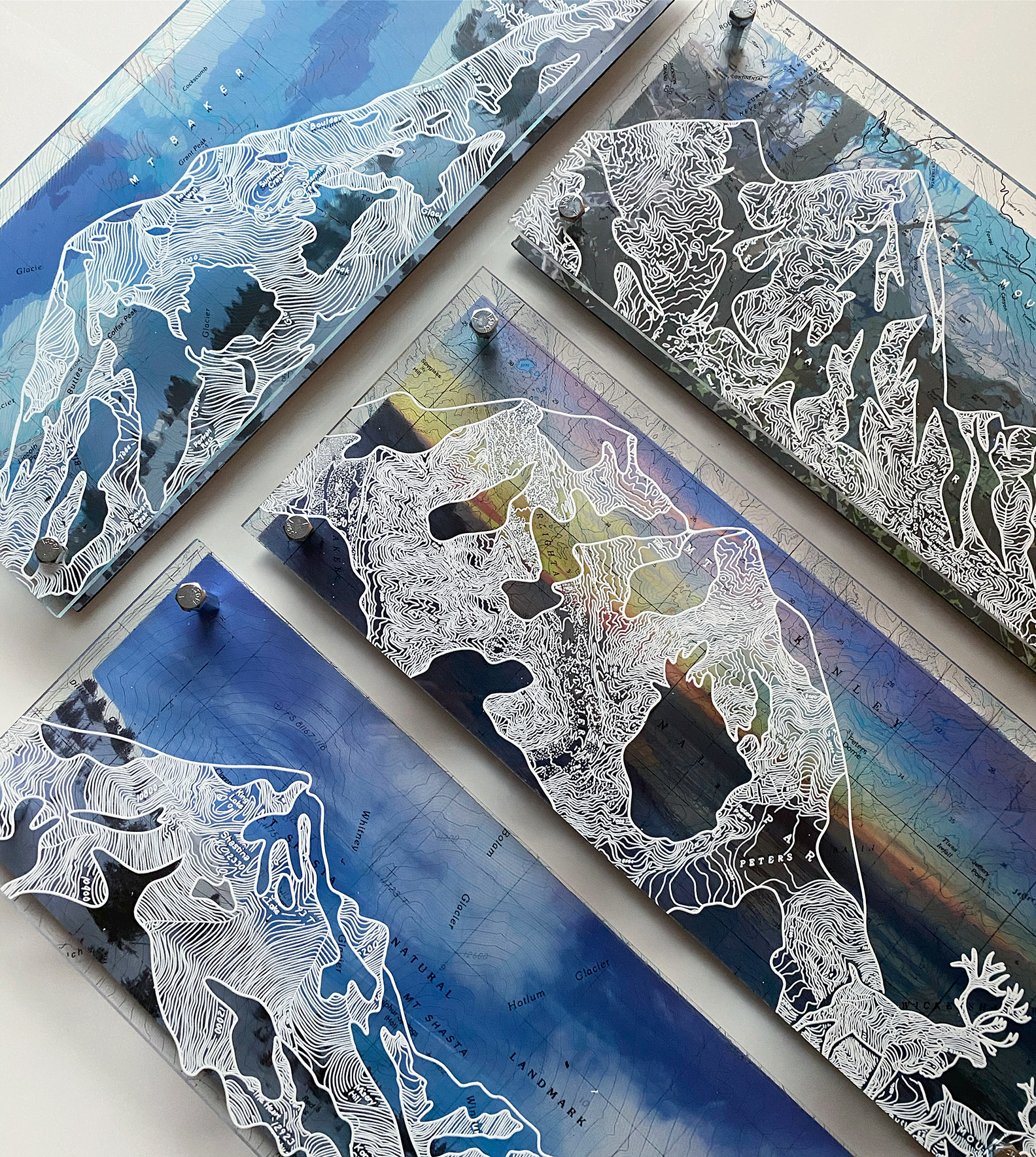
I design maps on plexiglass and illustrate silhouettes by hand -drawing over the the lines in the topography. The maps and silhouettes are backed with colorful, original photographs that I took where the map is from. The different layers are all tied together with a little engineering and some zinc bolts :).
I love combining all these elements to create a sense of place, history and conservation. The national parks are my favorite places to showcase (and visit) and incorporating the landscape and wildlife into my work makes me really happy!
The finished result is a 2-d, “frameless”, layered piece that is bright, unique and centered around the map, location and the natural environment.
(even the lady is in her natural state)
:)
See more on IG @ instagram.com/modernterrain
More info: instgram.com
Denali

Mt. McKinley / Denali & some reindeer drawn over a vintage map when Denali was still called Mt. McKinley (I ❤️ history)
I took the background photograph on a wintery day in Anchorage- we never made it to Denali but I could see it when the sun came out.
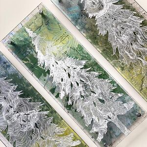
Layers and Layers of Trees on a Mt. Rainier Map

Giant double layered forest from a Mt. Rainier map – this one took weeks to finish! Backed with a photograph I took on the mountain.
Mountains 😍

Peaks drawn from various topographic maps around the US – I am working on a collection from every peak across the country, and I have to go see them all first :)
Three Sisters

Little Descutes Map with the silhouette of Three Sisters drawn from the topography – this happens to be one of my favorites and a great place to hike!
Magic :)

White maps are magical! Designed “by accident” when I inverted a map I was working on in photoshop. I decided to go with it and I love it so much!
(This one is hanging in my home ❤️)
Yellowstone Bison

Bison / Buffalo on a topo map of Yellowstone National Park- Sometimes I use the photo to place the silhouettes- I designed this one in photoshop to make sure the bison were “standing” on the mound in the background before I drew it all out. I took the photo at Old Faithful just a few years ago.
Tahoe Aspen

My heart for old maps – this ons is from 1908 and features all the shops and families based around the lake, the details create really unique designs in the illustration and the blue in the lake makes this map so beautiful!
Rocky Mountain National Park

The silhouette of this great park drawn from a map of Estes and the mountain range- I went to Colorado to take photos for an upcoming art show but almost every day was super cloudy! Luckily it was sunny one day and I got this fun photograph at Bear Lake.
Joshua Tree

1958 map of Joshua Tree National Park
I love the vintage maps and try to match their sentiments with iconic images from the past. This map is before Joshua Tree was a national park – it says “National Monument” instead.
Giant Cedar

Despite the HOURS it took to fill in all these amazing lines this has to be one of my favorite pieces ever, the colors of the background and scale of the tree work so well together! (Mt. Rainier Map featuring the dome)
Top View – showcasing layers :)

Yosemite Lady

I spent a week day exploring Half Dome and Yosemite in 2019- the whole time I was there I felt so at peace and tranquil so I drew this lady feeling the same way. Photo taken at Half Dome, map from Yosemite National Park
Wasatch

The details in the map make my time at work really – I think these deep canyon zig-zag maps are my favorite to draw on, they are so medatative.
(Wasatch mountains on a Little Cottonwood Canyon Map)
Me, at an art show before Covid :)

The good old days…
Now I am mostly selling on line and taking on lots of commissions. I am so grateful to be able to to continue to be an artist even with everything closed for the moment!


7
0