ADVERTISEMENT

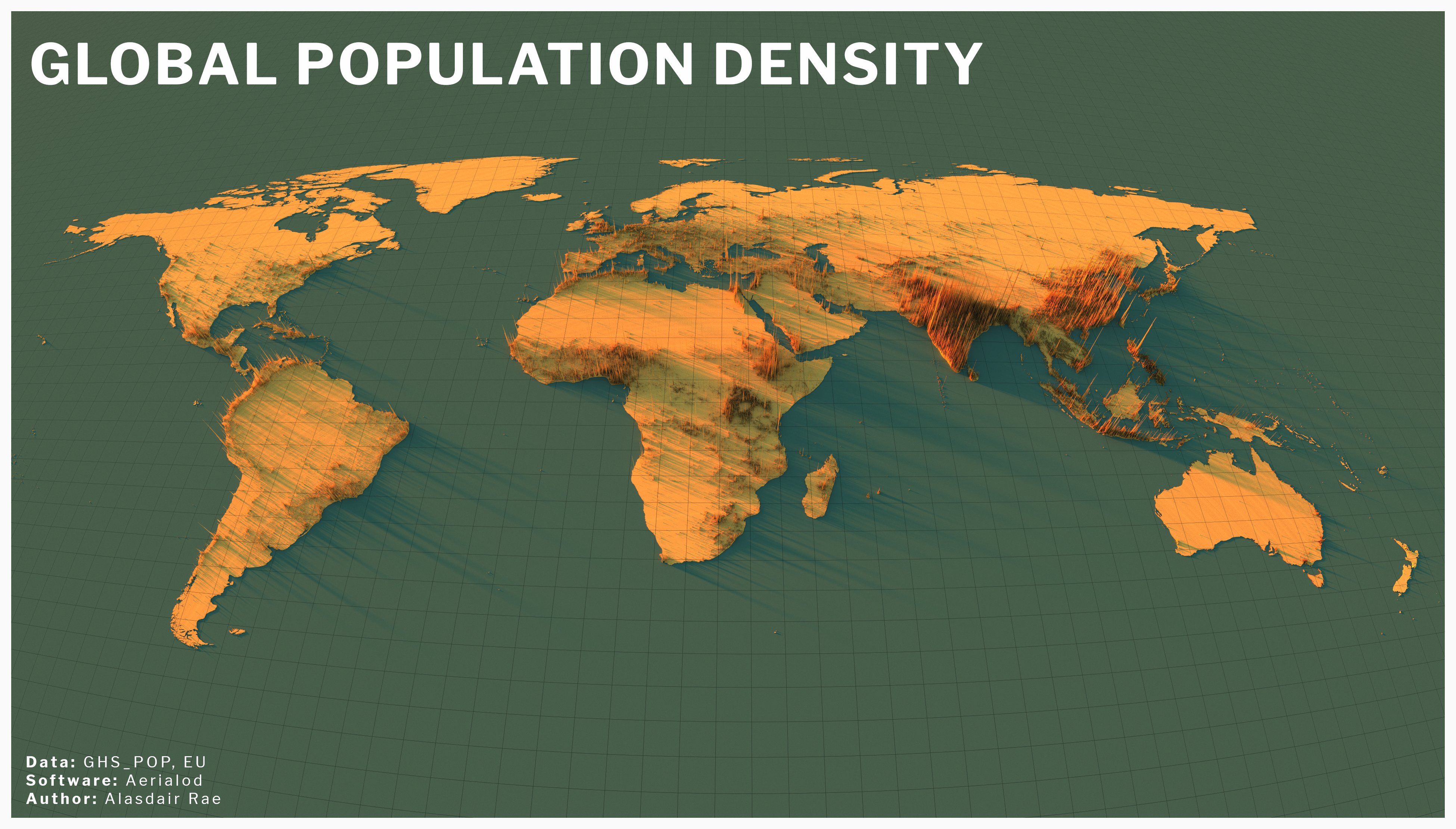
Twitter user Alasder Ray ( @undertheraedar ) decided to visually visualize the Earth’s population density.

To do this, he used statistics and special programs to display the necessary information in the form of peaks. Having picked up a beautiful colour scheme, Ray was able to clearly demonstrate how our world is differently populated, and this is much more interesting than the boring cards with circles, which we are used to at school!

More info: socoolsogood.com

RELATED:

    36. The whole world.

    35. The Arabian Peninsula.

    34. Taiwan.

    ADVERTISEMENT

    33. The Gulf of Thailand: Singapore, Kuala Lumpur, Medan, Aceh, Bangkok, Phnom Penh, Ho Chi Minh City and Hanoi at the top right, if you look closely.

    32. View of Canada: Montreal, Cornwall, Ottawa, Kingston, Toronto, Hamilton, North Bay, Sudbury and even Winnipeg in the distance.

    ADVERTISEMENT

    31. India and Sri Lanka.

    30. India and neighbors.

    ADVERTISEMENT

    29. In this view: Cairo, Istanbul, Tbilisi, Baku, Tehran, Baghdad and many other interesting places.

    28. Africa + neighbors.

    ADVERTISEMENT

    27. View from the east over Madagascar.

    ADVERTISEMENT

    26. View from the east over the Sahara.

    25. A view from the north over South Africa through Cape Town.

    24. View of Nigeria.

    ADVERTISEMENT

    23. Africa: view from the south over the Mediterranean and Egypt.

    ADVERTISEMENT

    22. Philippines.

    21. In the center is Indonesia, but Malaysia, Brunei, East Timor, Singapore, the Philippines, parts of Thailand, Myanmar, Cambodia and Vietnam, parts of Australia and Hainan are also visible.

    20. Hawaii.

    ADVERTISEMENT

    nineteen.

    ADVERTISEMENT

    18. Alaska (and part of Canada).

    17. China + Seoul in the upper right.

    16. China + Hanoi, bottom left.

    ADVERTISEMENT

    15. Japan.

    ADVERTISEMENT

    fourteen.

    13.

    12. South America.

    ADVERTISEMENT

    11. New York and the east coast.

    ADVERTISEMENT

    10. North America, the Great Lakes region.

    nine

    8. Australia.

    ADVERTISEMENT

    7. New Zealand.

    ADVERTISEMENT

    6. 48 continental states of the USA.

    5. East view over the Baltic Sea. Bottom left is St. Petersburg, in the middle is part of Finland, and in the distance are Britain and Ireland.

    4. View of Europe from the south.

    ADVERTISEMENT

    3. View from Iceland.

    ADVERTISEMENT

    2.

    1. Europe.