Get Premium
Dark mode theme is available exclusively for premium users. Learn more about the benefits of subscribing.
No fees, cancel anytime.

 Dark Mode Ad-Free Browsing Unlimited Content
 Ad-Free Browsing Unlimited Content Dark Mode
Join 1.2 million Panda readers who get the best art, memes, and fun stories every week!
Photographer Benjamin Grant has set off on a mission to change the way we see our planet with his stunning photo project - Daily Overview.
Every single day, Grant shares one satellite photo from Digital Globes to change the way we see our planet. "With a focal length 16 times longer than a standard DSLR camera, the cameras are so powerful that you can take a picture of a beach ball on the Golden Gate Bridge in full resolution…from Los Angeles," Grant told Bored Panda. "I try to present the images with no bias and let people decide what these altered landscapes mean, based on the facts and the visual evidence in the frame. I believe that this perspective is a means to start a conversation about the condition of our planet and how we can better protect it."
"I create the images by stitching together numerous high-resolution satellite photographs. I partnered with a satellite company called DigitalGlobe and accordingly have access to their full archive of imagery. Once I have put together a composite image, I then treat it like a photograph to make it as crisp and easy to understand as possible to accentuate certain patterns, colors, or places." The results are so amazing, Grant has even put together a book of over 200 high-resolution satellite photographs. It's titled "Overview: A New Perspective of Earth", and can be purchased through Amazon.
More info: Amazon | Website | Instagram
This post may include affiliate links.
45.904892400°, 13.317671100°. Here’s one of my favorite images from the 'Where We Design' chapter in “Overview”. The town of Palmanova, Italy is recognized by its concentric layout known as a star fort. The rationale for this construction was that an attack on any individual wall could be defended from the two adjacent star points by shooting the enemy from behind. The three rings that surround Palmanova were completed in 1593, 1690, and 1813.
-33.6787655, 151.3160979. Check out this incredible shot of the ocean pool at Mona Vale Beach, located in the suburbs of Sydney, Australia. There are a number of public ocean pools in New South Wales, offering stunning areas to swim, situated on the rocky coast, with waves splashing into the pool.
“Overview” — Valparaíso, Chile is built upon dozens of steep hillsides overlooking the Pacific Ocean. Known as “The Jewel of the Pacific,” the city is the sixth largest in the county and is home to approximately 285,000 residents. To learn more about the book, click here:
53.0066°N 7.1920°E. Bourtange is a village with a population of 430 in the municipality of Vlagtwedde in the Netherlands. The star fort was built in 1593 during the Eighty Years’ War when William I of Orange wanted to control the only road between Germany and the city of Groningen. Bourtange was restored to its mid-18th-century state in 1960 and is currently used as an open-air museum.
26.386332°, – 80.179917°. Residential development is seen in Boca Raton, Florida, USA. Because many cities in the state contain master-planned communities, often built on top of waterways in the latter half of the twentieth century, there are a number of intricate designs that are visible from the Overview perspective. Boca Raton is home to roughly 91,000 residents.
Stunning blue waters surround and pass through the tidal channels of islands in the Bahamas. Small tidal changes on the banks cause water to flow through the narrow channels between the islands, first in one direction and then the other. The darker blue sections of water are the deepest parts of the channels and the surrounding light blue color is more shallow (less than 25 meters / 80 feet). This photo was captured from the International Space Station and is courtesy of NASA
This solar concentrator in Seville, Spain use 2,650 heliostat mirrors to collect and focus the sun’s thermal energy to heat molten salt flowing through a 460-foot tall central tower. The molten salt then circulates from the tower to a storage tank where it is used to produce steam and generate electricity. In total, the facility displaces approximately 30,000 tons of CO2 emissions every year.
24.445187, 54.719998. The Al Falah Housing Project is located in Abu Dhabi, United Arab Emirates. The development covers 12.5 million square meters with 4,857 villas as well as mosques, schools, a shopping mall, and a hospital.
The Arabs build just about everything on such a GRAND scale. I find it interesting how many of their architectural masterpieces can only be fully recognized from the air.
Salt and clay pan located on the edge of the Namib Desert in Namibia. These reddish sand dunes of the desert, seen in the top half of this Overview, are among the tallest in the world, with many rising more than 656 feet (200 meters).
30.089890096°, 38.271806556°. Center pivot irrigation is used throughout the Wadi As-Sirhan Basin of Saudi Arabia. Water is mined from depths as great as one kilometer (~3,000 ft), pumped to the surface, and evenly distributed by sprinklers that rotate 360 degrees. Spurred by a government effort to strengthen its agriculture sector, cultivated land in Saudi Arabia grew from 400,000 acres in 1976 to more than 8 million acres by 1993. For a sense of scale, the total area shown in this Overview is approximately forty square miles (32,000 acres).
23°09′32″N 102°44′41″E. Rice paddies, constructed in steps, cover the mountainsides of Yuanyang County, China. Cultivated by the Hani people for the last 1300 years, the slope of the terraces varies from 15 to 75 degrees with some having as many as 3,000 steps. As we’ve been getting a lot of questions recently about prints, I want to mention that this Overview, and many others, can be purchased directly from our website in the Printshop section!
Besides growing rice, it looks like hillside excavating is the job to have in that section of county.
37.714546°, -6.532834°. Fruit trees swirl on the hills of Huelva, Spain. The climate here is ideal for this growth with an average temperature of 17.8° C (64° F) and a relative humidity between 60% and 80%.
32°51'6"S 70°8'16"W. Los Caracoles Pass, or The Snails Pass, is a twisting mountain road located in a remote section of the Andes Mountains on the Chilean side of the border with Argentina. The path climbs to an elevation of 10,419 feet, has no roadside safety barriers, and is frequented by large trucks.
I find it interesting that from above it comes across as a only zig zag road and not a climbing road.
42°4′27″N 87°41′3″W
The Baha'i House of Worship in Wilmette, Illinois, is the oldest surviving Baha'i House of Worship in the world and the only one in the United States. The building contains an auditorium that seats 1,191 people beneath a 138 foot-high (42 m) domed structure. You’ll also notice that many components of the complex come in sets of nine as the number symbolizes perfection and completion in the Baha'i faith.
55 ° 38 ’12.836031 “N, 12 ° 23′ 58.386726″ E
43.077305°N 79.07562°W. Niagara Falls is the collective name for three waterfalls that straddle the border between Ontario, Canada and the United States. Horseshoe Falls is seen here. The falls have the highest flow rate of any waterfall in the world, with a vertical drop of more than 165 feet (50 m). The Maid of the Mist, also visible here, is a boat that has carried passengers into the rapids below the falls since 1846.
33.6189504, -112.291099. Houses, built in concentric circles, make up a section of Sun City, Arizona, USA. When the development opened on January 1, 1960, the event attracted a crowd of more than 100,000 onlookers and the "futuristic development" was featured on the cover of Time magazine.
41.394921°N 2.175507°E. Plaça de Tetuan is a major square located in the Eixample district of Barcelona, Spain. The area characterized by its strict grid pattern, octagonal intersections, and apartments with communal courtyards.
19.420511533°, -99.08808712°. This week we will be looking at fascinating examples of urban planning - a major focus of the Where We Design chapter in our new book “Overview”. To start off, here is one of our favorite shots of the radiating streets that surround the Plaza Del Ejecutivo in Mexico City, Mexico. If you have examples of other cities that you think might look particularly mesmerizing from above, please let us know in the comments on Facebook.
40°47′13″N 119°12′16″W. Over the next few days, thousands of people from around the world will head to the desert in Nevada, USA to construct Black Rock City. Laid out in a grid plan with radiating avenues named after the numbers on a clock, the city serves as home to roughly 60,000 people for Burning Man, an annual week-long event. Burning Man is described as an experiment in community, art, self-expression, and radical self-reliance. Additionally residents in Black Rock City practice one of the event's key principles of ‘Leave No Trace’ – meaning significant efforts are taken to make sure as the city is disassembled in the days following the festival, the desert returns to its original state.
29°58′34″N 31°7′58″E. The Great Pyramids of Giza are located on the outskirts of Cairo, Egypt. Dating back to 2580 BC, the Great Pyramid, the largest structure at the site, is the oldest of the Seven Wonders of the Ancient world and the only one to remain largely intact. With an estimated 2,300,000 stone blocks weighing from 2 to 30 tons each, the 481 foot pyramid was the tallest structure in the world for more than 3,800 years.
40°46’56”N; 73°57’55”W. Central Park in New York City spans 843 acres. That’s 6% of the island of Manhattan.
37.5106531, -122.053325. The salt evaporation ponds seen here cover roughly 10 square miles (26 square km) in San Francisco Bay, California, USA. Salt is extracted from the water here through a lengthy process. First, water from the bay is channeled into massive basins where it begins a transformation into brines. Over five years, the brines evaporate, concentrate, and travel several miles before they are collected as pure salt crystals. The massive ponds get their vibrant color from a particular species of algae (Dunaliella) that thrives in extremely salty water and produces a red pigment.
Train cars filled with coal are stationed in Norfolk, Virginia. Operated by the Norfolk Southern corporation, Lamberts Point Pier 6 is the largest coal-loading station in the Northern Hemisphere and serves at the temporary depot for the company’s fleet of 23,000 coal cars.
Angkor Wat — a massive temple complex surrounded by a moat in Cambodia.
28.614656°, 77.057758°. Delhi, India contains approximately 16 million residents. The neighborhoods of Santosh Park and Uttam Nagar, both pictured here, are home to some of the city’s poorest people and contain its most built-up and densely populated land. Numerous studies have shown a correlation between the wealth of a residential area and its total number of trees and the amount of green space. This Overview is a particularly striking example of that trend.
32.151087°, –110.826079°. The largest aircraft storage and preservation facility in the world is located at Davis-Monthan Air Force Base in Tucson, Arizona, USA. The boneyard—run by the 309th Airspace Maintenance and Regeneration Group—contains more than 4,400 retired American military and government aircraft.
34°35′51″N 117°22′59″W. Here’s one of my favorite images from the Where We Waste chapter of “Overview”. The Southern California Logistics Airport in Victorville, California contains an aircraft boneyard with more than 150 retired planes. Because the demand for jumbo jets has dropped significantly in the last two decades in favor of smaller, more affordable twin‑engine planes, many large aircrafts such as Boeing 747s have been retired. The dry conditions in Victorville – located on the edge of the Mojave Desert – limits the corrosion of metal, meaning planes can be stored here for years while they are stripped for spare parts.
48.8738°N 2.2950°E. Bastille Day or La Fête National as its known in France. The holiday commemorates the start of the French Revolution which began in 1789 with the Storming of the Bastille, a fortress and prison. In modern times, the day's most celebrated event is a military parade through Paris that begins at the Arc de Triomphe - seen in this Overview - and ends at Place de la Concorde. Joyeux Quatorze Juliet!
40°41′21″N 74°2′40″W. The incredible shot shows the Statue of Liberty in New York City. The colossal copper structure depicts a robed female figure — Libertas, the Roman goddess of liberty — who bears a torch and a tablet upon which is inscribed the date of the American Declaration of Independence — July 4, 1776. The statue is an American icon of freedom and a welcoming sight to immigrants arriving from abroad.
63.7751116, -18.09628. Glacial melting and flooding occurs every year by the Skafta River in Iceland. As the water travels down towards the North Atlantic Ocean, incredible patterns are created on the hillsides. Rising lava, steam vents, or newly opened hot springs can all cause this rapid ice melt, leading to a sizable release of water that picks up sediment as it flows down from the glaciers.
37.007977710°, -6.049280818°. The Lebrija 1 Solar Power Plant in Lebrija, Spain is comprised of approximately 170,000 individual mirrors installed on 6,048 parabolic troughs. If placed next to one another, the troughs would extend for 60 kilometers.
60.152008, 24.921262. Löyly is a public sauna located on the edge of the Baltic Sea in Helsinki, Finland. The building, constructed with repurposed wood, features a shell-like design that has been described as a “tunturi” - the Finnish word for something in between a hill and a mountain. In total, Finland contains approximately 3.3 million saunas or roughly one per household. This incredible shot was shared with us by @joelmiikka
Istanbul is the largest metropolitan area in Turkey, with a population of more than 14 million people.
37.802317, -122.419740. Lombard Street runs from east to west in San Francisco, California, USA. With eight hairpin turns dispersed over a one-block section in the Russian Hill neighborhood, Lombard is often referred to as "the most crooked street in the world.”
Lombard street is actually over rated. It is not the most curvy street in the US or even San Francisco, it is just in the touristy area of town and they decided to play up this street. I know as I lived in SF for over 10 years.
40.67693°N 117.23193°E
I thought it was just a 'fire break' - I didn't know until I read the title. Amazing!
33°51′31.2″S 151°12′50.5″E. The Sydney Opera House hosts more than 1,500 shows each year in its various performance halls, drawing a total attendance of approximately 1.2 million people. While the buildings famous “shell” design appears uniformly white from a distance, it actually features a subtle chevron pattern composed of tiles in two colors: glossy white and matte cream.
5°00′N 48°16′E. Waves roll into the shores of Somalia, by the village of El Hur. Located on the Horn of Africa, Somalia has the longest coastline on the mainland continent, stretching for more than 3,000 kilometers (1880 miles).
31.633080724°, -7.986173343°. The medina quarter in Marrakesh, Morocco is characterized by its winding, maze-like streets. Because the intricately connected honeycomb of alleyways narrows to less than a meter wide (~ 3 feet) at certain spots, the area is generally free from car traffic.
37°54′31″N 121°36′01″W. Discovery Bay is a waterfront community built on a network of man-made dikes in Contra Costa County, California, USA. Development of the area began in 1964 is now home to roughly 13,352 residents. As seen in this Overview, many residents have private docks with boat access to the Sacramento–San Joaquin River Delta.
25°50′17″N 50°36′18″E. Durrat Al Bahrain will consist of 15 connected, artificial islands (including six atolls, five fish-shaped, and two crescent-shaped). Construction costs are estimated at $6 billion and the project is slated for completion in mid-2015.
33.800083, -84.451936. The Norfolk Southern Railway operates 21,300 miles of track in 22 states, primarily in the Southeastern US. Inman Yard in Atlanta, Georgia, pictured here, is one of the major railyards that houses a portion of the operation’s 3,648 locomotives and 79,082 freight cars.
18°44′N 7°23′E. With just three days until the release of “Overview”, I’m sharing a few of my favorite images from the book. Here’s one from the chapter all about mining, ‘Where We Extract’. The Arlit Uranium mine is located in Arlit, Niger. French nuclear power generation as well as the French nuclear weapons program are dependent on the uranium that is extracted from the mine - more than 3400 tonnes per year.
Ever wondered how the moon affects the tides of water on Earth? Long story short, it’s gravity. As the moon orbits the Earth, it exerts a gravitational pull on the Earth. Since the Earth is significantly larger, it doesn't actually move towards the moon, but the water on it's surface, being liquid, does move.
41.75283°, 73.506694°. Malé is the capital and most populous city in the Republic of Maldives. With more than 47,000 residents per square kilometer (0.39 square miles), the heavily urbanized city constitutes the fifth most densely-populated island in the world. Malé and the other islands of the Maldives are located one meter (3 feet) above sea level.
36.78234°N 2.74315°W. Plasticulture refers to the practice of using plastic materials in agricultural applications. This is visible in the plains and valleys of Almeria, Spain where nearly 20,000 hectares are covered by these greenhouse structures.
36.211001, -115.266914. The Desert Shores Community in Las Vegas, Nevada contains 3,351 units and four man-made lakes.
37.9137118, -122.368161. Cars are unloaded and parked at an automobile terminal in Richmond, California, USA. In 2015, 17.5 million cars and light trucks were sold in the United States, raising the total number of registered vehicles in the country to roughly 253 million.
37°31′S 177°11′E. Whakaari, also known as White Island, is an active stratovolcano, situated 48 km (30 mi) from the North Island of New Zealand in the Bay of Plenty. Whakaari is New Zealand’s most active volcano, and has been built up by continuous eruptions over the past 150,000 years. The island is approximately 2 km (1.2 mi) in diameter and rises to a height of 321 m (1,053 ft) above sea level.
34°55′16″S 57°57′16″W. The planned city of La Plata, the capital city of the Province of Buenos Aires, is characterized by its strict grid pattern. At the 1889 World’s Fair in Paris, the new city was awarded two gold medals for the “City of the Future” and “Better performance built.” This is the fifth of seven posts in our week focused on urban planning.
22°59′01″S 43°12′16″W. All of the exciting coverage at the Olympics has us thinking of this beautiful Overview of Ipanema Beach in Rio de Janeiro! Frequently recognized as one of the most beautiful beaches in the world, its 2.25 miles of sand are divided into segments by lifeguard towers known as "postos.”
52°39′57″N 09°28′56″E. Fields surround the residential area of Rodewald, Germany. The agricultural village was first mentioned in historical records from the early 13th Century and is now home to 2,549 people.
40°40′54″N 74°09′02″W. Shipping containers are stacked at the Port Newark Container Terminal in Newark, New Jersey, USA. The massive facility handles over 600,000 shipping containers every year and has begun expansion projects that will increase annual capacity to 1.1 million containers by 2030.
49°00′33″N 8°24′14″E. The city of Karlsruhe, Germany was planned with a palace tower at its center, surrounded by 32 radiating streets. Because the design resembled the ribs of a folding fan, the city is sometimes called the “fan city” or “Fächerstadt." Additionally, this city's urban plan gave rise to the geometry concept of “Karlsruhe Metric” which refers to a measure of distance that assumes travel is only possible along radial streets and along circular avenues around the center.
52°18′N 5°10′E. Naarden is a star fort in the Netherlands. The city was constructed in the manner seen here so that an attack on any individual wall could be defended from the two adjacent star points by shooting at the enemy from behind. Today Naarden is home to roughly 17,000 residents.
The Bicycle Snake (or Cykelslangen) is a 200-meter long ramp in Copenhagen, Denmark. The structure was created because 12,500 cyclists needed to bring their bikes up and down a large staircase each day. Instead of just replacing the staircase with a ramp, the architects proposed a plan with a new and beautiful approach to navigating the area. The Bicycle Snake now meanders 6-7 meters above the sea's surface and is painted in a bright orange color to increase visibility for cyclists.
25.783216°N 80.16052°W. Palm Island and Hibiscus Islands are two man-made islands located in Miami Beach, Florida. While the residential neighborhoods on the islands have some of the highest property values in the city, they are also among the first places ordered to evacuate in advance of a hurricane.
41.8798146,-87.618203. Sailboats are docked at DuSable Harbor in Chicago, Illinois, USA. The facility is located on Lake Michigan in the heart of the city’s downtown area and contains 420 slips for boats between 30 to 60 feet in length.
33°56′33″N 118°24′29″W. This morning I’m flying to Los Angeles for a couple of days through the city’s international airport, commonly referred to as LAX. Last year, the facility handled nearly 75 million passengers, making it the seventh busiest in the world.
33°38′12″N 084°25′41″W. Hartsfield–Jackson International Airport in Atlanta, Georgia, USA is the busiest airport in the world by total passengers and number of flights. In 2015, ATL accommodated more than 101 million passengers and 882,000 flights. Dozens of planes departing and arriving at concourses A-D are seen in this Overview.
20°54′N 107°12′E. Hạ Long Bay, located in the Quảng Ninh Province of Vietnam, is a stunningly beautiful destination. Here, towering limestone pillars and tiny islands topped by a rich, green forest rise from the beautiful waters of the Gulf of Tonkin. Halong translates as 'where the dragon descends into the sea' and local legend suggests that this seascape was created when a great mountain dragon charged towards the coast, its flailing tail gouging out the valleys and crevasses in its path.
30°37′35″N 122°03′53″E. The Port of Shanghai is the world’s busiest container port, handling more than 35 million TEUs (approximately 776 million tons) of cargo every year. That weight is roughly equal to 1.7 times the mass of all humans living on the planet.
19°22′26.07″N 99°5′18.38″W. Thousands of trucks and cars surround the Central de Abasto - Mexico City’s largest wholesale market for produce and other foodstuffs. The market serves more than 300,000 people and handles over 30,000 tons of merchandise each day —representing 80% of the consumption of the Mexico City metropolitan area.
55°45′N 37°37′E. Moscow is the capital and largest city in Russia with 12.2 million residents. The city is organized into five concentric transportation rings that surround the Kremlin. The two innermost rings are seen here.
37°34′23″N 7°58′15″W. Waste ponds are seen at the Neves-Corvo Mine in the Castro Verde Municipality in Portugal. Zinc and copper and the primary resources extracted from the mine and the byproducts of that extraction is sent to these basins three kilometers away. Typically, once waste materials are pumped into a tailings pond, they are mixed with water to create a sloppy form of mud known as slurry. The slurry is then pumped through magnetic separation chambers to extract usable ore and increase the mine’s total output.
6.104°S 106.8865°E. Dozens of massive cargo ships and tankers - some weighing up to 300,000 tons - are anchored outside the Port of Tanjung Priok in Jakarta, Indonesia. The facility is the country's busiest and most advanced seaport, handling more than 50% of Indonesia's trans-shipment cargo. The port is also among the least efficient in all of Southeast Asia, due to slow customs handling and limited docking capacity.
33.9287°N 118.281°W. Today I'll be traveling throughout the freeway network of Los Angeles, well known for its massive interchanges (and traffic). The Judge Harry Pregerson Interchange is a stack highway interchange located near the Athens and Watts neighborhoods in South LA. This junction is composed of five levels that scale to a staggering height of more than 40 meters (132 feet).
41°52′57″N 87°37′08″W. This Overview shows Maggie Daley Park in Chicago, Illinois, USA. The park’s Buckingham Fountain stands out in this Overview with its ornate design and serve as a gathering point for thousands of visitors at the Lollapalooza festival this weekend.
From 1962 until 2002, Rotterdam was the world’s busiest port, but was overtaken first by Singapore and later by Shanghai.
37.336147372°, 126.718586767°. Jeongwang-dong is an industrial sector in the city of Ansan, South Korea. The Korean government intensively drove a plan to develop the modern city, particularly in this area, with an emphasis on manufacturing. The striking blue color that you see here results from the use of aluminum roofing, which is used for its low cost and longevity.
5°40′S 52°44′W. Clearcutting operations in the Amazon Rainforest of Para, Brazil branch out from one of the state’s central roads.
31.079844, -97.80145. In 2013, there were 923,400 home construction projects in the United States.
38°53′26″N 77°1′13″W. The city's L'Enfant Plan was developed in 1791 by Major Pierre Charles L'Enfant for George Washington, the first President of the United States. L’Enfant designed a compass-aligned grid for the city’s streets, with intersecting diagonal avenues that were later named after the states of the union. The diagonal avenues also intersect with the north-south and east-west streets at circles and rectangular plazas in order to create more open, green spaces. Lastly, L'Enfant laid out a 400 foot-wide (122 meter) garden-lined “grand avenue” - what is now know as the National Mall – that connects the US Capitol Building, the Washington Monument, and the Lincoln Memorial (the latter two are visible at right in this Overview).
51°30′26″N 0°7′39″W. London is the capital and most populous city in the United Kingdom.
26°22′7″N 80°6′0″W
40°25′10″N 3°38′26″W. Our Lady of Almudena Cemetery in Madrid, Spain is one of the largest cemeteries in the world. The number of gravesites – estimated at five million – is greater than the population of Madrid itself.
35°18′29″S 149°07′28″E. The construction of Parliament House in Canberra, Australia involved the removal of the top half of Capital Hill (the mound on which the structure was built). After the project was completed, much of the displaced earth was replaced on top of the building where a lush, green lawn now grows. While much of Canberra was designed by by Walter Burley Griffin in 1913, this specific complex opened in 1988, is designed to look like two boomerangs, and contains approximately 4,400 rooms.
39°27′53″N 0°22′12″W. The urban plan of the L’Eixample district in Valencia, Spain is characterized by long straight streets, a strict grid pattern crossed by wide avenues, and apartments with communal courtyards. A similar layout was used for the district of the same name in Barcelona. The circular structure in the upper right is the Plaza de Toros de Valencia - the city’s largest bullfighting arena.
41°02′43″N 29°02′04″E. The Bosphorus Bridge is one of two suspension bridges that connects Europe and Asia across the Bosphorus Strait in Istanbul, Turkey.
Good old Dagenham! Scrolling through all 103 pictures, didn't expect to see that here! My mum was born at Becontree Ave, the road that runs top to bottom on the left. An innovative bit of urban planning, in it's day (1920's). If you look at Google Maps satellite view with Valence Avenue in the centre, zoomed out a bit from the detail in this photo, you'll be surprised how much green space and the number of parks within a five mile radius. Dagenham-a...c36b3d.jpg 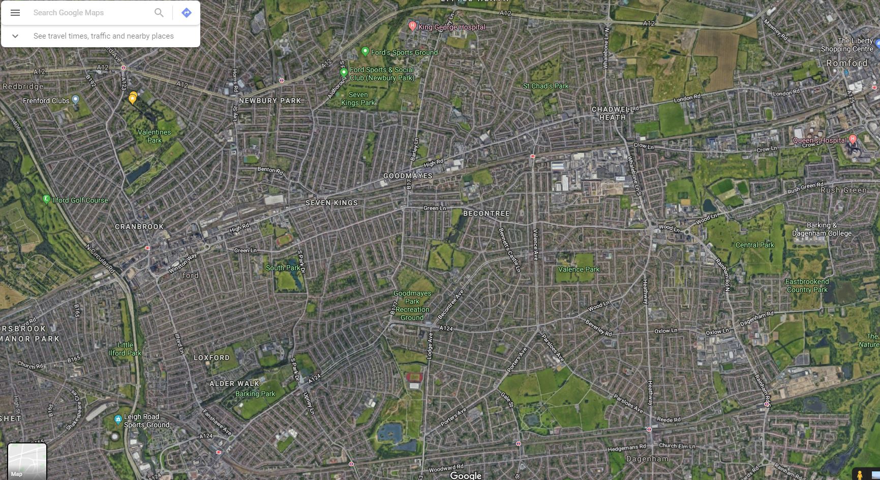
My flight to Seattle-Tacoma International Airport will be one of the roughly 380,000 aircraft movements that take place at the facility each year and I will be one of roughly 42 millions passengers that travel through the airport annually. The facility also contains a 13,000-car parking garage, the largest structure of its kind in North America, which is visible at the top of this Overview.
48°55′28″N 2°21′36″E. In a less than an hour, France will square off against Portugal in the finals of Euro 2016 — the championship tournament of European football (soccer) that takes place every four years. The match will be played in Stade de France, the nation’s largest stadium that has a seating capacity of 81,338. Enjoy the game!
8°6′43.2″S 79°1′43.68″W. Trujillo is the second largest city in Peru with slightly less than 800,000 residents in its urban area. España Avenue - the circular road that is visible at the center of this Overview - contains the city’s monument area and also traces the historic outline of the defensive wall that was constructed around the city in 1786.
41°4′15.480″N 71°51′25.528″W. Montauk Point Light is a lighthouse located at the easternmost point of Long Island in the hamlet of Montauk, New York. With its construction authorized by George Washington in April 1792, the building was the first of its kind in New York and is the fourth oldest active lighthouse in the United States.
10°30′N 66°55′W. Caracas is the capital and largest city in Venezuela, with more than three million residents. In recent months, plummeting oil prices combined with a significant drought has created a dire situation in cities across the nation. Four hour blackouts are now a regular occurrence and some regions go without power for days at a time. Most supermarkets have almost no food to sell, hospitals have no medicine, and crime is rampant and escalating.
38°52′48″N 77°04′12″W. In honor of Memorial Day in the United States, we’ve selected an Overview of Arlington National Cemetery outside of Washington, D.C. Since the American Civil War, the 624-acre cemetery has become the final resting place for veterans of the nation’s conflicts. The structure seen here is the Arlington Memorial Amphitheater that also contains the Tomb of the Unknown Soldier.
35.9663844, -83.929399. A highway interchange connect Interstates 40 and 275 outside of Knoxville, Tennessee, USA. Because of its intertwined construction, a structure like this is commonly called a “spaghetti junction.”
25.783742, -80.128644. Umbrellas and beachgoers dot the sands of Miami Beach, Florida, USA. This area is one of the most popular tourist destinations in the country, attracting nearly 15 million visitors each year.
40°40′54″N 74°09′02″W
40.360051, -3.564548. The A-3 and M-50 highways come together in an interwoven crossroads southeast of Madrid, Spain. This structure is commonly called a “spaghetti junction.”
23.7675749, 90.318299. Kilns for firing and making bricks are scattered across the landscape in Dhaka, Bangladesh. Almost all bricks in the country are made using a 150-year-old process where soil is mixed with water, formed into bricks using wooden molds, left to dry in the sun, and then burned in these orange, traditional kilns. As the widespread use of old kilns has hampered air quality in the country, local groups and the government have been working hard to increase the use of "clean" brick kilns with more sustainable technology.
38°45′01″N 120°20′00″W. 20 acre clearcutting tracts in the El Dorado National Forest.
32.170890°N 110.855184°W

A whole new perspective AND appreciation for what we have, and what we've built.
These are indeed some of the MOST STUNNING photos I've seen in my life!!!!!
These are gorgeous; some of them are like abstract paintings, others are like mathematically precise arrangements. Well seen, well captured!
A whole new perspective AND appreciation for what we have, and what we've built.
These are indeed some of the MOST STUNNING photos I've seen in my life!!!!!
These are gorgeous; some of them are like abstract paintings, others are like mathematically precise arrangements. Well seen, well captured!


 No fees, cancel anytime


, Madrid, Spain")


