35 Informative Maps People Shared On This Group That Might Change Your Perspective On Things (New Pics)
Where would you start if you were looking for a treasure? Well, from what we learned in Jumanji, we probably need a map. In fact, maps, the precious representation of information, are key to so many secrets of the world, whether it’s the Earth, our history, politics, sociology, or anything, really.
Thanks to this corner of Reddit known for being the ultimate destination for fans of cartography, we can devour an endless variety of maps that all differ in information, style, size and other features. With 1.8 million members of the community, it’s now turning into one of those Reddit powerhouses that gives the best of online content.
Scroll down through the new batch of maps below and after you’re done, be sure to share our previous posts with the most unique and informative diagrammatic representations you may not have even known existed, here, here and here.
This post may include affiliate links.
The Baltic Way. On 23 August 1989, Two Million People Joined Their Hands To Form A Human Chain Spanning 675.5 Km Across The Three Baltic States. The Protest Was Against The Soviet Occupation, And To Support The Independence Movements Of The Three States


Cyclist Recreates Nirvana’s “Nevermind” Album Cover

Bored Panda reached out to the subreddit’s founder Patrick to find out how Reddit's cartography powerhouse has been doing since we last spoke a while ago. He describes himself as “a Denver-based techno-geek with a focus on all things geospatial and cartographic and a coding hobbyist with an emphasis in geospatial applications.”
“The subreddit has been stable the last few months, however, that all changed this morning with the news out of Ukraine of the military action there,” he said. “The subreddit usually has between 2,000 and 4,000 users at a given moment on a normal day. That number spiked to a peak of over 20,000 users looking for current maps of the situation there.”
Topography Of China

All Roads Lead To Rome. This Map Is Visualises The Famous Roads Built By The Roman Empire

Atheists Are Prohibited From Holding Public Office In 8 US States

Patrick believes that the way people think of cartography is changing. “The previous generation was accustomed to paper maps that they used to navigate. This required skills in orientation and awareness that are no longer necessary with digital maps on mobile devices. Whilst there are lots of articles that eulogize the loss of these skills, I don't think it's necessarily all bad.”
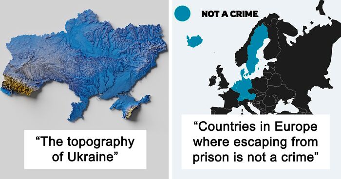
The Topography Of Ukraine

Russian attack on the Ukraine started today at night. I'm devastated.
Map Showing Netherland's Progress In Flood Management (Source: Earthmagazine)
")
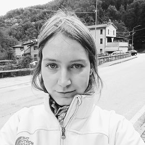
Is Escape A Crime?

According to Patrick, the history of cartography is full of changes in how maps are created and used. And right now, “we're seeing another shift in response to the digital age.” The sub’s founder explained that “the digital generation has a heightened awareness of how maps can visualize data. The tools to make maps have been democratized. This has increased interest in finding new and clever ways to see spatial data.”
“I think the hottest trends are in maps that elucidate some sort of political understanding. These can be maps of elections, voting districts, gerrymandering, political recognition, voting patterns, etc. Social media is engineered to spur controversy and this is most apparent in hot button political topics. Politically themed content will garner more discussion, controversy and comments than most other topics.”
All The Countries That Have Gained Independence From Great Britain

Hence the old saying, "The sun never set on the British Empire."
Load More Replies...7/4/1976- this is why the US celebrates the Fourth of July. 7/4/1976 was a big a deal since it was 200 year anniversary
Load More Replies...Also the countries who's treasures have been put into the British Museum against their will?
Tonga was never a British colony and never relinquished its sovereignty to any foreign power. So how can I trust the rest of the publications on this site?
Tonga was a "British Protectorate" from 1901-1970, while officially independent, the british controlled their foreign affairs, military protection, and used the British Military to prevent rival tribal leaders from claiming the throne from the brits ally royal family there.
Load More Replies...Australia has been an independent Country since 1901, not sure why it's shown as 1942
Like a lot of things, it was in stages. https://www.australiaunwrapped.com/when-did-australia-become-fully-independent/#
Load More Replies...And you'll be able to add Scotland to the list in a couple of years.
Scot here. I'm genuinely glad that all these countries have independence. Not sure why anybody wouldn't be but Scotland's always hated England
or all the countries that were screwed by the british empire. The queen doesn't have much longer to apologise for the atrocities perpetrated on the native inhabitants in the name of the empire
Shouldn't the Brits be ashamed of what it had done in the past? I mean these were places taken control from their local people by the Brits.
Seriously? Why should today's Brits be ashamed of what our ancestors did? WE didn't do it. Are you ashamed of the bad things your country did in the past? Practically every country has something. Be ashamed of actions today - that's all we have control of and in many instances even that is minimal.
Load More Replies...They invaded these native’s lands, and in most cases committed genocide to claim it.
My mum was taught that 'the sun never sets on the British Empire' at school. She remembers colouring it pink on a map of the world.
The countries in the EU were never part of the British empire
Load More Replies...No wonder Canada, Australia, and New Zealand still have another country's leadership all over their money. They just got independence like a burp and two farts ago.
Perhaps, but without any bloodshed. Canada is still a constitutional monarchy within the Commonwealth. Hence, her face.
Load More Replies...Beavers In Europe, 1900 And 2021

That's fantastic! Beavers are a "keystone species", that make massive contributions to the health of forests, wetlands, waterways, and even water tables! The American West is the place where they're needed most, they were almost killed off by fur traders and other interlopers, and if we had more beavers... we'd have less drought and fewer wildfires.
Most Popular Language On Duolingo

Patrick is a member of #maptime Denver, Rocky Mountain Map Society, NACIS, PLSC, Charles Close Society and Open Street Map Foundation. So he always has a new project up his sleeve. Right now he’s working on building a plugin for QGIS, an open-source map-making software.
“The topic is map projection distortion. We all know that flat maps distort the shape of the Earth. However, visualizing this is quite difficult. My plugin will work so that a user can input a projection and a given region. The output will be a map overlay that shows where the scale is closest to true and where it falls below a given threshold,” he told us and added that he’ll be happy to share it when it's finished.
Countries With A Higher Life Expectancy Than The United States

The New Longest Possible Train Journey In The World

The Red Part Contains More People Than The Blue Put Together

Russian Military Build-Up Around Ukraine

A Map Visualizing The Armenian Genocide - Started 106 Years Ago

World Map, But It’s Centered On Buenos Aires, Argentina

London's Piccadilly Tube Station. Piccadilly Circus Is A Road Junction And Public Space Of London's West End In The City Of Westminster. It Was Built In 1819 To Connect Regent Street With Piccadilly

Countries That Have, Or Have Had, Openly Gay Heads Of Government

That should read "European countries." New Zealand has had a gay head of state.
This Is A Really Fascinating Map. Languages Of Europe Around 600 Ad

World Map According To China In 1799

US States In Which Homosexuality Was Illegal From 1962 To 2012

Map Of The 2191 Meter Deep Krubera Cave. The Deepest Known Cave System In The World


This Is The Farthest Place On Earth From Any Ocean

Google: "The most distant point from an ocean is the Eurasian Pole of Inaccessibility (or "EPIA") 46°17′N 86°40′E, in China's Xinjiang region near the border with Kazakhstan. Calculations have shown that this point, located in the Dzoosotoyn Elisen Desert, is 2,645 km (1,644 mi) from the nearest coastline."
% Of Europeans Who Would Fight For Their Country

Map For Halloween - Every Castle In Europe

The last time this map was on here, it got torn to shreds about its sheer inaccuracy. It doesn't classify most actual castles as castles, especially in the UK and Spain, but it does count palaces and chateaux (which includes mansions and large stately homes in France only). I live a five minute walk from an actual bloody castle and it is not on this.
Most Obese Countries

Age Of Women At Birth Of Their First Child (Europe)
")
Fascinating if this map could be compared with ones from 50 and 100 years ago.
School Shootings In Europe Since 2010

Map Presenting Coldest Temperatures Ever Measured In Celcius...

Piracy In The 21st Century

Grading System In Europe

Most Frequent Causes Of Deaths For 50 To 69-Year-Olds. @realworldmaps


Eu Countries Pushing To Label Nuclear Power As Green Energy

Nuclear energy confuses me; it's clean yet we have no idea what to do with the waste it produces so (to my knowledge) the strategy now is to store it in the earth and figure it out in 100 years :/
Note: this post originally had 131 images. It’s been shortened to the top 35 images based on user votes.

This is really not very well constructed and is missing data, explanations etc.
Since anyone can write for Bored Panda, would you like to write a better article? ☺️ I would enjoy reading one with more detailed information to go along with the maps!
Load More Replies...If these overly critical, pseudo intellectuals are so upset about what is presented here, then by all means please rewrite this post. It will give other overly critical, pseudo intellectuals something to criticize. For me, and I'm sure many others, I thoroughly enjoyed this post. Finding and posting all of this interesting information took a lot of time and effort that I appreciate. Keep up the good work, we're counting on you!
