This Is What The World Looked Like 300 Million Years Ago
If you ever think about our geographical perception of the world, a map with 7 continents probably pops into your head instantaneously. Even though that image is correct to the present day, not a lot of people tend to remember the map is constantly shifting. A new country pops up every once in a while, continental borders change due to climate change. But all that is a very insignificant shift compared to what happened to our planet between 150-300 million years ago. These maps reveal how it changed over the years until it got to the point that resembles the world as we know it today.
It’s hard to believe but a long time ago, the world as we know it might have been one huge continent

Even though there was some speculation about the movement of continents back in the 16th century, this theory was left rejected and underdeveloped for almost 4 centuries for lack of any motive mechanism. However, some scientists lingered on the idea for a while after it was rejected in 1596 but were unable to back it up with enough scientific evidence. That was until Alfred Wegener’s paper was published in 1912.
There’s a theory that it assembled from previous continental units approximately 335 million years ago

The enormous continent began to break up again sometime about 175 million years ago

Wegener was a geophysicist and meteorologist who finally made a decent breakthrough by figuring out that fossils of similar animals and plant fossils and similar rock formations from the same time period can be found on different continents. He was also the first to propose the term “continental drift”.
The theory that continents have moved away from each other was first introduced by Abraham Ortelius in 1596

Some scientists backed up that speculation but Alfred Wegner was the first to come up with quite a complete theory in 1912

Scientists most commonly tend to see similar fossils of various kinds as stronger evidence of continental drift and the complementary arrangement of the facing sides of continents such as South America and Africa, for example. Although, biology professor Matthew Wills claims that this map of conjoined continents is nowhere near as accurate as claimed as much of the continent existing for 300 million years has been subducted and a new crust has developed.
According to him, continental drift would also explain why similar animal and plant fossils are found on different continents

Even though it faced loads of rejection in the 1910s-1950s, evidence of the movement of continents is now extensive

92Kviews
Share on Facebook

When this will stop? We'll hit the ice walls! Let's Make Pangea Great Again!
This... is news to people? I was taught this back when I was 10, in the 80s. This should be common knowledge.
Just as you were once 10 and learned this for the first time, someone is now 10 and learning this. It wasn't common knowledge for you before that.
Load More Replies...The viewer always has to keep in mind that this is only an approximate solution. Also the continental shelves down to a depth of some 200 metres (600-700 feet) belong to the continents, but aren't included in above maps.
Load More Replies...This actually happened several times in Earth's history. Pangea is just the youngest and best known supercontinent.
Man, my city (Lima, Peru) didn't have an ocean coast, just more like a lake
They've got Scotland and England & Wales wrong. Scotland was originally attached to what is now Manhattan and eventually joined up with England and the rest of Europe. The make up of the bedrock of Scotland matches Manhattan and is completely different to England.
Great lakes on the map from 300 million years ago. They weren't there 25000 years ago.
They took present day shapes and put together where the country/region used to be. Notice the shapes, the gaps, other body of waters like nowadays rivers and Lake Victoria
Load More Replies...No, thanks. Too much exposure to the open seas for the coastal areas, not enough sea for the inland.
Load More Replies..."continental borders change due to climate change." Okay, climate change is now responsible for shifting continental borders? Now I've heard everything. The fact this s**t is polluting science is disgusting. Yeah climate change is real but ffs it didn't cause my carpet to wear prematurely. It's blamed for absolutely everything. Virtue signalling woke people are literally the worst. I like lawyers and thieves better than these people.
has anyone done a projection of where we will all be in another 100, 200 or 300 million years?
So U.S. had waves of immigrants from its southern border since this moment?
They have the great lakes on the map. They weren't there 25,000 years ago lol
Even though I can see how they used to be connected, I can't conceive of one unified land mass. There must have been other islands that don't exist any more. It just doesn't make sense that there was just gigantic island surrounded by a vast ocean. Nature doesn't work like that.
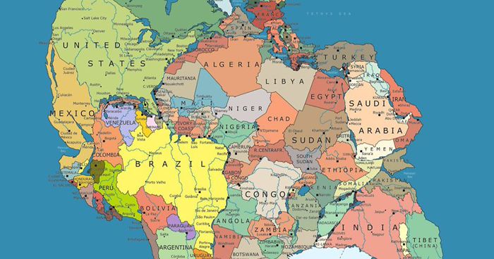
What is going on with that present day picture? India is not part of Asia and Europe doesn't exist? When did the continents change?
Ouch... there are a lot of angry sphere earthers in here today.
Load More Replies...When this will stop? We'll hit the ice walls! Let's Make Pangea Great Again!
This... is news to people? I was taught this back when I was 10, in the 80s. This should be common knowledge.
Just as you were once 10 and learned this for the first time, someone is now 10 and learning this. It wasn't common knowledge for you before that.
Load More Replies...The viewer always has to keep in mind that this is only an approximate solution. Also the continental shelves down to a depth of some 200 metres (600-700 feet) belong to the continents, but aren't included in above maps.
Load More Replies...This actually happened several times in Earth's history. Pangea is just the youngest and best known supercontinent.
Man, my city (Lima, Peru) didn't have an ocean coast, just more like a lake
They've got Scotland and England & Wales wrong. Scotland was originally attached to what is now Manhattan and eventually joined up with England and the rest of Europe. The make up of the bedrock of Scotland matches Manhattan and is completely different to England.
Great lakes on the map from 300 million years ago. They weren't there 25000 years ago.
They took present day shapes and put together where the country/region used to be. Notice the shapes, the gaps, other body of waters like nowadays rivers and Lake Victoria
Load More Replies...No, thanks. Too much exposure to the open seas for the coastal areas, not enough sea for the inland.
Load More Replies..."continental borders change due to climate change." Okay, climate change is now responsible for shifting continental borders? Now I've heard everything. The fact this s**t is polluting science is disgusting. Yeah climate change is real but ffs it didn't cause my carpet to wear prematurely. It's blamed for absolutely everything. Virtue signalling woke people are literally the worst. I like lawyers and thieves better than these people.
has anyone done a projection of where we will all be in another 100, 200 or 300 million years?
So U.S. had waves of immigrants from its southern border since this moment?
They have the great lakes on the map. They weren't there 25,000 years ago lol
Even though I can see how they used to be connected, I can't conceive of one unified land mass. There must have been other islands that don't exist any more. It just doesn't make sense that there was just gigantic island surrounded by a vast ocean. Nature doesn't work like that.
What is going on with that present day picture? India is not part of Asia and Europe doesn't exist? When did the continents change?
Ouch... there are a lot of angry sphere earthers in here today.
Load More Replies...
219
43