Someone Just Pointed Out How Messed Up New Orleans Map Is And Now We Can’t Unsee It
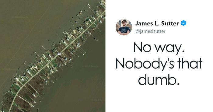
Last week, James L. Sutter, a 34-year-old game designer, and author, took to Twitter to share his hilarious tongue-in-cheek critique on the real map of New Orleans.
Sutter, best known as the co-creator of the Pathfinder Roleplaying Game, an expansion to Dungeons and Dragons 3rd edition, took a look at New Orleans maps as if it was a fantasy location, designed and submitted by a freelancer.
Playfully highlighting some seemingly nonsensical bridge placement on the funny map, and the fact that Lake Borgne doesn’t appear to be a lake at all, the cartography of Louisiana’s largest city was quickly picked apart by the author. He concluded that it is a really interesting map, but in the end, it’s just not believable. Please clean up your map drawing and resubmit when it follows the rules of a real-world city.
We guess that whoever designed the map for New Orleans was tripping on something, but doesn’t it look like an interesting place to go and check out? What can be cooler than a place that, according to Sutter, is stranger than fiction? Scroll down below to check out his critique and the cool images for yourself, and let us know what you think in the comments!
More info: Twitter
Last week, game designer James L. Sutter took to Twitter to share his critique on the real map of New Orleans

Sutter is best known as the co-creator of the Pathfinder Roleplaying Game

Having the expertise on fictional map creation, the author criticized it’s many seemingly nonsensical parts

Like this canal that is perfectly linear…

Or why is Lake Borgne called ‘lake’ when it’s technically a lagoon?

And then the placement of Lake Pontchartrain Causeway that expands for 24 miles (38km)?

Sutter elaborates on the texture of the swamps of Louisiana, pointing out that no cartographer would work on replicating it

While admitting that the design is quite interesting, James Sutter concludes that the map is simply not believable

He jokingly recommends the South to rework the map of New Orleans and resubmit it when it looks like a real city

299Kviews
Share on Facebook

i used to have a fear of bridges spanning a large body of murky water...as a kid, i experienced sheer terror every time we had to traverse the insanely long Pontchartrain bridge or the Atchafalaya Basin bridge...it didn't help that my little brother would say " the bridge is going to fall" when we drove across it, either, the little sh*t 😄
As someone from New Orleans, I speak for all of us when we say that we refuse to resubmit any maps. Have you ever met anyone from this area? We are some of the most hard headed and stubborn people on the planet. Why do something easy when we could go batshit crazy and build a 24 mile bridge! This is also (probably) the only city in the country where you have to go east before you can go west (our roads are REALLY backwards). Also, a vast majority of the people here completely insane and we wouldn't have it any other way!
One too many coconuts to the head during Mardis Gras eh?
Load More Replies...lol I've had to drive on those roads before and bridges, hes spot on and FUNNY.. It's OK o laugh :)
I like that he's a game deaigner or whatever too, it's almost like they should be a god of graphic designing and remake the world. :p Reninds me of Dark Cloud right now. XD
Load More Replies...My brother is a Civil Engineer and we happen to live only a few hours away and visit often. He said New Orleans created their own elevation datum (not mean sea level like the rest of the country) so they wouldn't appear to be below sea level as they actually are. That was actually the largest problem with Hurricane Katrina by the way--the levies broke and the entire town flooded and stayed that way.
Hilarious, AND TRUE!! I have been ALL over that city, and the city planner, and folks from the roads dept were DEFINITELY hopped-up on something when all this s**t went down! And people wonder why it is hell on earth when there is a hurricane!!! THIS should answer ALL of the questions!
I can see why it flooded so easy. What insurance company would ever cover anything in that area?
a century of corruption and this is the result. the long way. the hard way. pay me.
This is a blatant rip off of somone else who did this years ago. But better. And without being rude.
The intelligence of this guy to do write up this very humorous post just is beyond my ability to understand.
All to facilitate navigation obviously....the author cannot be that ignorant can he ?
Honestly would love to see what the hell the architects were thinking with some of these choice. Is this a result of flooding? Still doesn't explain that bizarre bridge... yeah, I think New Orleans not existing is the more reasonable explanation.
Lake Pontchartrain is only 12 feet deep on average. Building a bridge across that is much less difficult than the Flodida Keys causeway.
Load More Replies...I crossed that bridge on the Amtrack train The Crescent. It's sure for real. And I'll never forget how amazing it was
I was born in Lake Charles...I'm in Anchorage Alaska...bridges to nowhere here...I'm loving this planet and it's inhabitants.
Well for the bridge thing it's technically in the middle and would probably attract the most people and be easy to find, albeit probably get the most traffic because of it. :p Some people from the west or east side would probably have to drive extra far just to use it. Though maybe that's still eadier than making and going across a much longer bridge...
On the up side, the whole city is going to be under water within the next 25-30 years, so mapping it is probably a waste of time anyway.
But that's kind of decades away... I'd imagine it should only take 5-10 years at most to make a map I think so it could still be relevant. :p
Load More Replies...It takes a really twisted person to make a map funny. We need more of them. (Twisted persons, not maps.)
It's NOT a real city. It's the filthiest, most disgusting and dangerous places I've ever been too.
This is what happens when cities were built before they could fly over them and actually see what was going on. "Head THAT way. If something gets in your way, turn".
Dear New Orleans, WHY THE HELL DO YOU LOOK LIKE SOMETHING OUT OF WoW???? TOO GODDAMN PERFECT


Do me a favor, look up the word Satire in the Dictionary.
Load More Replies...i used to have a fear of bridges spanning a large body of murky water...as a kid, i experienced sheer terror every time we had to traverse the insanely long Pontchartrain bridge or the Atchafalaya Basin bridge...it didn't help that my little brother would say " the bridge is going to fall" when we drove across it, either, the little sh*t 😄
As someone from New Orleans, I speak for all of us when we say that we refuse to resubmit any maps. Have you ever met anyone from this area? We are some of the most hard headed and stubborn people on the planet. Why do something easy when we could go batshit crazy and build a 24 mile bridge! This is also (probably) the only city in the country where you have to go east before you can go west (our roads are REALLY backwards). Also, a vast majority of the people here completely insane and we wouldn't have it any other way!
One too many coconuts to the head during Mardis Gras eh?
Load More Replies...lol I've had to drive on those roads before and bridges, hes spot on and FUNNY.. It's OK o laugh :)
I like that he's a game deaigner or whatever too, it's almost like they should be a god of graphic designing and remake the world. :p Reninds me of Dark Cloud right now. XD
Load More Replies...My brother is a Civil Engineer and we happen to live only a few hours away and visit often. He said New Orleans created their own elevation datum (not mean sea level like the rest of the country) so they wouldn't appear to be below sea level as they actually are. That was actually the largest problem with Hurricane Katrina by the way--the levies broke and the entire town flooded and stayed that way.
Hilarious, AND TRUE!! I have been ALL over that city, and the city planner, and folks from the roads dept were DEFINITELY hopped-up on something when all this s**t went down! And people wonder why it is hell on earth when there is a hurricane!!! THIS should answer ALL of the questions!
I can see why it flooded so easy. What insurance company would ever cover anything in that area?
a century of corruption and this is the result. the long way. the hard way. pay me.
This is a blatant rip off of somone else who did this years ago. But better. And without being rude.
The intelligence of this guy to do write up this very humorous post just is beyond my ability to understand.
All to facilitate navigation obviously....the author cannot be that ignorant can he ?
Honestly would love to see what the hell the architects were thinking with some of these choice. Is this a result of flooding? Still doesn't explain that bizarre bridge... yeah, I think New Orleans not existing is the more reasonable explanation.
Lake Pontchartrain is only 12 feet deep on average. Building a bridge across that is much less difficult than the Flodida Keys causeway.
Load More Replies...I crossed that bridge on the Amtrack train The Crescent. It's sure for real. And I'll never forget how amazing it was
I was born in Lake Charles...I'm in Anchorage Alaska...bridges to nowhere here...I'm loving this planet and it's inhabitants.
Well for the bridge thing it's technically in the middle and would probably attract the most people and be easy to find, albeit probably get the most traffic because of it. :p Some people from the west or east side would probably have to drive extra far just to use it. Though maybe that's still eadier than making and going across a much longer bridge...
On the up side, the whole city is going to be under water within the next 25-30 years, so mapping it is probably a waste of time anyway.
But that's kind of decades away... I'd imagine it should only take 5-10 years at most to make a map I think so it could still be relevant. :p
Load More Replies...It takes a really twisted person to make a map funny. We need more of them. (Twisted persons, not maps.)
It's NOT a real city. It's the filthiest, most disgusting and dangerous places I've ever been too.
This is what happens when cities were built before they could fly over them and actually see what was going on. "Head THAT way. If something gets in your way, turn".
Dear New Orleans, WHY THE HELL DO YOU LOOK LIKE SOMETHING OUT OF WoW???? TOO GODDAMN PERFECT
Do me a favor, look up the word Satire in the Dictionary.
Load More Replies...
302
55