30 Unusual Maps People Shared On This Group That Might Change Your Perspective On Things
Interview With AuthorFor many of us, cartography day in geography or history class meant a quick nap. With our eyes open, we’d dream of all the delicious stuff we were gonna eat after school, of music we’d play on the Walkman, of a message we received the other day from that cutie…
To bring back our long-lost excitement for hard pieces of data, aka maps, plans, and geographic drawings, we're gonna need to start from the very best of them. Luckily, there’s a whole online community on Reddit dedicated to the most unusual charts of geographic areas that took maps to a whole new level.
From mapping "October" in European languages to mapping an eagle’s track over a period of twenty years, these incredible examples will surely put the world into a completely new perspective.
Who knows, you may well unleash your inner cartographer and become among 1.1 million like-minded members of the maps subreddit. In that case, you may need some more cartographical goodness with 41 maps that portray lesser-known facts about America.
This post may include affiliate links.
An Image Of GPS Tracking Of Multiple Wolves In Six Different Packs Around Voyageurs National Park Shows How Much The Wolf Packs Avoid Each Other's Range


To Increase Local Tourism, Lithuania Has Made A Map With Magnets That You Can Only Find In Corresponding Cities

Occupied Bald Eagle Nests In Wisconsin. 1974 vs. 2019. Growth Credited To The Clean Water Act

To find out more about this amusing Reddit community by the name r/MapP**n, Bored Panda reached out to its creator Patrick McGranaghan, who started the subreddit in 2011 while living in Taiwan.
Patrick said he has always been a map geek: “I wanted people to share those maps so that they are easy to find and discuss.”
It turns out, he works as a land surveyor in Colorado and is a devoted member of several map societies across the nation, including the North American Cartographic Information Society, Charles Close Society for the Study of Ordnance Survey Maps, and Rocky Mountain Map Society, to name just a few.
Tracking Of An Eagle Over A 20 Year Period

When A Band Announces A World Tour

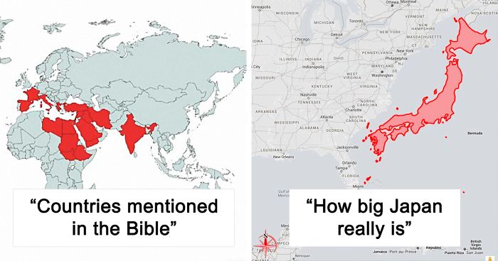
Japan, How Big It Is In Reality?

Okay, mind blown; it's literally twice as big as I'd imagined given typical maps. Thank you, person who made it!
Visit thetruesize.com and you can do this with any country, it's really fun.
Load More Replies...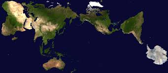
When I was a young rocket engineer, I got the chance to work in Japan for several years on the Japanese space program to launch weather and communication satellites. We had a great class taught by a professor from the University of California Sacramento about Japan. He said that the islands of Japan were physically about the same size as the state of California. In 1977 the population of America was about 200 million people and the population of Japan was about 100 million people. He said that Japan had about 40% usable land - there's a large part that's swamp land or the Aleutian island chain. California by comparison has about 60% usable land. The Sierra Nevada mountains and the dessert occupy the remainder. I always remember his final statement: Take half the entire population of the United States and move them all to California. Now take away 1/2 the usable land. That's how crowded Japan is.
That’s a really interesting perspective...especially since I’m a Californian!
Load More Replies...The bottom right most red dot of an island, still part of Tokyo.
Different map projections screw up sizes a lot, the standard Mercator projection for example makes Greenland look like the size of Africa while it's actually much smaller. Consequences of try to fit a round Earth onto a flat map.
still smaller than Ontario with more people in it than all of Canada
This is only helpful if I know how big the US "really" is, which I don't, unless it's next to a map of Europe.
That U.S. is roughly 3000 miles/5000 km east to west and 1000 miles/1600 km north to south.
Load More Replies...Landmass is roughly the size of California. Farmland and liveable land is about 2/3 that.
It's a mountainous country so most of the population is concentrated in very large cities. Of course you could say the same about Texas and Alaska.
Wow! I didn't realize how small the East Coast of the US is! I thought we were much BIGGER than that!
Alaska: 663,300 mi², Quebec: 595,391 mi², Ontario: 415,600 mi², British Columbia: 364,764 mi², Texas: 268,597 mi², Alberta: 255,541 mi², Saskatchewan: 251,700 mi², Manitoba: 250,116 mi², France: 248,573 mi², Spain: 195,364 mi², Sweden: 173,860 mi², California: 163,696 mi², Japan: 145,937 mi², Germany: 137,988 mi², Finland: 130,672 mi², Poland: 120,726 mi², Great Britain and Ireland: 113,418 mi², Great Britain: 80,823 mi²
India: 1,269,000 mi², Saudi Arabi: 830,000 mi², Alaska: 663,300 mi², Quebec: 595,391 mi², Ontario: 415,600 mi², British Columbia: 364,764 mi², Texas: 268,597 mi², Alberta: 255,541 mi², Saskatchewan: 251,700 mi², Manitoba: 250,116 mi², France: 248,573 mi², Spain: 195,364 mi², Sweden: 173,860 mi², California: 163,696 mi², Japan: 145,937 mi², Germany: 137,988 mi², Finland: 130,672 mi², Poland: 120,726 mi², Great Britain and Ireland: 113,418 mi², Great Britain: 80,823 mi²
Did Japan take control of the arrow pointing North at some point?
There's a lore what I know/barely remember is where a sword was dipped in the water and the dripping water formed the land. :)
126 million people in Japan, compared to 326 in all of the US. They are not wasting any space
Hee, hee... That's reality? Ye gads! I thought they were on the other side of the world!!
For more of this kind of thing check out http://mapfrappe.blogspot.com/p/mapfrappe-index.html
And they are quite a bunch of Daredevils too! All cities are all on the Pacific side 😳.
Japan seems to be slightly southerly, but I’m looking at a not-great map.
Load More Replies...very confusing placing Japan right next to USA for comparing the size....
The creator said that the title r/MapP**n followed the trend on Reddit at the time when “there were a lot of subreddits with a *-porn suffix.” He explained further: “This refers to pictures of innocuous things like nature, architecture, or engineering marvels in a beautiful way. It was not meant to be sexual. The internet at the time was a lot more relaxed and using that term was funny.”
“In the years since the culture on the internet has taken a much more puritan bias and some people don't like that name,” Patrick said.
However, he assured us that “the goal of the brand has not changed, though: it's a place to share and discuss beautiful maps.”
The Earth Being Centered On Great Britain Is Arbitrary, So Here's A Map Centered On New Zealand

Cheese Map Of Europe

The United States Of America: Alaskan Perspective

When it comes to submissions, they come in every form and style. “From historical maps showing ancient borders, to funny memes and transit maps. People also post imaginary maps of places that they create in their minds.”
In fact, every kind of map imaginable has been posted to this subreddit. Patrick said that linguistic maps are popular, as well as maps that re-imagine state and national borders. There are also maps of asteroids and maps of routes of famous explorers.
“One of my favorite interactions is when a map is posted of an obscure place and someone in the comments says they live there or has a story about that place.”
50 Percent Of Canadians Live South Of The Red Line

Each Section Has 10% Of The World's Population

List Of Countries Mentioned Or Referred In The Bible

Wow, I never knew this. Unlikely Jesus was fair skinned, blond and blue eyed....
Patrick concluded that “Maps are a way to visualize the world in a way that is easy to grasp. They are an aid in learning about new lands and faraway places. They help us find our way when we are lost.”
Especially in a time like now, “when the pandemic prevents us from traveling, maps are a way that we can travel without leaving our home,” the map enthusiast said.
The Longest Possible Train Travel In The World

Where Penguins Are Found Naturally In The World

Size Comparison Between Australia And The United States

3D Render Topographic Map Of Europe

I didn't know there was an ice-wall between Finland and Russia!?! (Do I need to write 'Sarkasm'?)
North America Animal Migration Routes

A Europe–U.S. Superhighway Proposed By The Former President Of Russian Railways

The Surface Of Mars: If, Like Earth, 71% Of Its Surface Area Was Covered With Water

World's Smallest Country vs. Largest Building

The Decline Of Our Native Tongue Over The Last 2 Centuries, I Find The Maps Rather Than The Reciting Of Statistics, Gives A Far Better Impression On The Overall Erosion Of One Of The Biggest Aspects Of Our Culture, Irish Itself

Worlds CO Emissions

Locations Johnny Cash Claims To Have Been In "Ive Been Everywhere"

The Countries That Got Tea Via China Through The Silk Road (Land) Referred To It In Various Forms Of The Word "Cha". On The Other Hand, The Countries That Traded With China Via Sea - Through The Min Tan Port Called It In Different Forms Of "Te"
 Referred To It In Various Forms Of The Word \"Cha\". On The Other Hand, The Countries That Traded With China Via Sea - Through The Min Tan Port Called It In Different Forms Of \"Te\"")
Passenger Railway Network 2020

In the "australia" map.... that little pink line above the "L", is actually New Zealand - a totally separate country to "Australia" (although the Aussies & Kiwis do consider themselves like "siblings" ie we are staunch rivals within sports, but stick together in defense of eachother).


What Pedestrians Look Like Across Europe

The Topologist's Map Of The World - A Map Showing International Borders, And Nothing Else

These Two Areas Of Africa Have Roughly Equal Populations

Roads Either Side Of The Border: Finland vs. Russia

Syria Before And After Civil War

Note: this post originally had 75 images. It’s been shortened to the top 30 images based on user votes.

Hello :) #24 is made by us at https://fb.com/indiainpixels - as the watermark says. Could you please source us instead? Thank you
Nearly all parts of knowledge are mixed like a kaleidoskop -fantastic
One of the most interesting things I've recently found on Bored Panda:) Love it:)
My heart was broken. I never believed I would get my ex back until Dr Akhigbe brought my ex in 48hrs with a powerful love spell. It is reliable to get a positive result, contact the spell caster for a love spell by email: drakhigbespellhome7@gmail.com or WhatsApp on +2349021374574.
