
30 Unusual Maps People Shared On This Group That Might Change Your Perspective On Things (New Pics)
There’s a wonderful online community on Reddit that’s dedicated to beautiful, intriguing, and artistic maps that will wow you and make you see the world from a whole other perspective. As someone who loves doodling maps in my spare time, I’m in heaven. And even though our generous and benevolent social media overlords [cough cough] don’t allow us to mention the full name of the subreddit because of one particular word that it uses, make sure you visit the group, check out their latest maps, and maybe even become members yourselves, dear Pandas!
In the meantime, let’s enjoy some gorgeous and interesting maps, shall we? Remember to upvote your fave pics as you continue scrolling. In need of an extra mega map fix? You’ll find Bored Panda’s previous posts about the ‘Map [Whoops Can’t Mention That Word Here Anymore]’ community right here, as well as here.
We reached out to the founder and moderator of the subreddit, Patrick McGranaghan. He told Bored Panda all about how his passion for maps was first sparked, as well as how amateur cartographers can develop their sense of style and design to create better maps and do their imaginations justice.
More info: Reddit | Twitter | Tumblr
This post may include affiliate links.
This Is My Wedding Gift To My Wife. We Get Married Next Sunday. I Used A Woodburning Kit To Burn A Map Of All The States We Have Visited As A Couple. We Both Love To Travel And Backpack Do I Want To To Keep Adding To It As We Get Older


Occupied Bald Eagle Nests In Wisconsin. 1974 vs. 2019. Growth Credited To The Clean Water Act

That's wonderful. It's so nice to see animal or bird populations increase like that. Thank you to all the conservationists who are making that happen.
USA In Drawn In 3 Lines. Boundaries Marked With Gaps (The Best I Could)
")
"I developed my passion for maps very early. My family traveled and moved around a lot. My dad taught me how to read maps and I would help him navigate. I used to flip through our Rand McNally atlas to pass hours traveling across the countryside. Maps are invitations to explore and visit new places. They give security in the knowledge that there's a way to get to your destination. If all else fails, a map will be your guide," Patrick shared how he first became acquainted with maps and how his passion grew. It hits close to home.
Patrick also reminisced about the moment he came up with the idea for the subreddit, back when he was living in a small flat in Taipei, in Taiwan. "I knew that I had a good idea and it felt almost electric. Like a fork in the road and your destiny is changing. When I moved back to the states I was able to find a career making maps (as a land surveyor) and I am grateful every day that I can do something that I love."
The World Of Infrastructure

United Kingdom

Light Blue Is A Map As We Know It And Dark Blue Is The Actual Size Of Each Country

Doing what we love for a living is a godsend. And though everyone might be there, plenty of us have felt the 'electric' feeling that Patrick's talking about where genuine excitement meets the potential for greatness.
Even though a lot of the amateur cartographers found on the subreddit have great ideas and are overflowing with creativity, their execution needs work to make the end results look less "hasty and skeletal." Patrick explained that some people need to develop their tastes for style and design. Luckily, he had some helpful tips for you and me.
"It is not that they are bad, it's just that they don't know that they can make their maps so much better. I'm talking about things like fonts and information boxes, detail and vicinity maps, adding gradients to water features, thoughtful color choices, shadows behind place markers. The subtleties are what make maps exquisite," he detailed.
A Map Of Finland's Bear Population, Made Up Of Bears

To Combat The Threat Of Desertification Of The Sahel (The Region Immediately To The South Of The Sahara), The African Union Is Leading An Initiative To Plant The Great Green Wall, A 7,775 Km (4,830 Mi) Belt Of Trees Crossing The Entire Breadth Of North Africa
, The African Union Is Leading An Initiative To Plant The Great Green Wall, A 7,775 Km (4,830 Mi) Belt Of Trees Crossing The Entire Breadth Of North Africa")
During the Dust Bowl in the US Midwest, President Roosevelt implemented a program to plant trees in rows as windbreaks to stop the wind from ripping up bare topsoil. The program worked well, and you can still see some of those trees standing today.
Just Walked In The Room And Found My 6 Year Old Drawing Countries By Hand

"The best way to learn how to do these things is to look at lots maps and see how other cartographers solve these problems. Imitate the masters. Read a few books on cartography and design. Some of the books that influenced me are 'Info We Trust' by RJ Andrews, 'Cartography' by Kenneth Field, and 'Things Maps Don't Tell Us' by Armin Lobeck. If you can integrate the ideas in these books you'll be a league above the average amateur cartographer."
As for the future? Patrick's waiting for the Covid-19 pandemic to die down and go traveling again. Among his plans is visiting the Baltic countries, especially the Soviet map store in Latvia.
Map I Made Out Of Pressed Flowers!

Can't tell but did they use a ☘ shamrock for Ireland (can't zoom in close enough 🙁) ?
Wolf Distribution In Italy From 1900 To 2020

Lol at first I thought it was just saying that there were only two wolves left in 2020.
This Is Awesome

With nearly 1.3 million members, the map-loving subreddit is a cartography powerhouse on the net (and it’s making me itch to start drawing a few maps of my own again). In June of 2020, the subreddit had just shy of a million members, so they're continuing to grow steadily.
The group has been on Reddit since the late spring of 2011 and will be looking forward to its 10th birthday in just a few short months. What with the rise and fall of online groups every single day, reaching the decade-long mark is no easy feat and it speaks to the quality of the content they share.
Indo-European Language Family Tree

To anyone wondering about why it's just Indo-European languages depicted: This info-graphic is part of a comic set in post-apocalyptic Scandinavia. A pandemic has killed most humans (and other mammals, too) and turned surviving infected into zombie-like creatures. The survivors have turned back to their old gods and rely on mages and cats to guard them from the trolls and beasts roaming in the un-cleansed areas. Stand Still, Stay Silent: http://sssscomic.com
The United States Of America: Alaskan Perspective

I Made A Retro Pixel Map Of The USA! Tried To Include Some Of The Iconic Monuments/Locations That Resonated With Me

In previous interviews with the founder of the subreddit, Patrick, Bored Panda learned all about the history of how the group was founded, as well as what kinds of maps you can expect to find. Patrick, a land surveyor from Colorado, founded the community while he was living in Taiwan in 2011.
A map geek through and through just like some of my colleagues and I, Patrick wanted to create a place where people could easily find and discuss beautiful maps. Patrick is also a member of the North American Cartographic Information Society, the Carles Close Society for the Study of Ordnance Survey Maps, the Rocky Mountain Map Society, among other groups.
Newspaper My Great Grandfather Saved From The End Of Wwii (I Have More Photos But This Subreddit Doesn't Allow A Gallery)
")
The Topography Of Italy

A Neat Little Map Guide

According to the founder, there was a time not too long ago when the internet was much more chill about using certain words while naming online groups. “In the years since the culture on the internet has taken a much more puritan bias and some people don't like that name,” he explained and I can’t help but agree with him—you have to really watch what you write and say nowadays. And the internet sometimes seems like it doesn’t understand subtlety, sarcasm, irony, or jokes anymore.
Euler Diagram-Map Of The British Isles

What The Netherlamds Would Naturally Look Like If They Hadn't Built Any Dikes To Prevent Flooding

If You Flew In A Straight Line From Mcallen, Texas To Bangkok, Thailand, You Would Only Spend About 50 Miles Over Water

Patrick explained to Bored Panda that there’s a bit of everything for everyone in the group: from historical and funny maps to imaginary and linguistic maps and more. “One of my favorite interactions is when a map is posted of an obscure place and someone in the comments says they live there or has a story about that place,” he said.
“Maps are a way to visualize the world in a way that is easy to grasp. They are an aid in learning about new lands and faraway places. They help us find our way when we are lost,” Patrick pointed out, adding that during the pandemic they can be great ways for us to travel while staying at home.
Map Of The 2191 Meter Deep Krubera Cave. The Deepest Known Cave System In The World

The Oldest Universities In Continuous Operation

Where Flamingos Are Found Naturally In The World

One of the categories on the subreddit is dedicated to political realignments that redraw borders and all I can say is that I’m a major fan. They’re imaginative, creative, funny, and make us look at history in an entirely different way. Playing ‘what if…’ games is a lot of fun.
Why do people love maps? Because they’re aesthetic. Because they’re like picture books for adults. Because you can get lost in them for days and they awaken your sleeping desire to go on an adventure. Because they reveal a novel way of looking at life that we’re not used to. And because squiggly lines are fun to draw. Or at least these are all the reasons why I love cartography (yours might be different).
Olympus Mons On Mars, The Largest Volcano In Our Solar System, Compared To Arizona

Relief Map Of Baltic And Scandinavia

Does anyone tilt their head and see it as a lizard chilling on a mossy rock?
The True Size Of New Guinea

Personally, I don’t mind that the map precedes the territory, no matter what Jean Baudrillard says. Why? Because, like unusual and intriguing books, they have ways of sparking new ideas and expanding our minds. Who needs the actual territory when we have such gorgeous maps to look at from the safety of our homes?
The Shire - English Counties Ending In 'Shire'

Satellite Map Of Vatican City

Europe Seen From Russia (Made In The 1950s)
")
Which map was your favorite one and why? What’s the most aesthetic or interesting map you’ve ever seen in real life? Do you have any maps at home? Are you a major geek like me and love drawing maps for your Dungeons & Dragons groups (I hope I’m not alone!)? Share your thoughts and, hopefully, your love for maps in the comment section below.
I Was Bored, So I Made The United States Of Christmas Cookies

Countries Who Call It 'Football' vs. Who Call It 'Soccer'

My Fiancée And I Got These Rings For Our Wedding Rings

Propaganda Made By The Allies During Ww1 Of What Will Happen To The Us If The Central Powers Won

Hand-Drawn Map Of The World In 1935

The Topography Of Japan

Paper Sizes World Map

Where Most Canadians Live (Red)
")
Extent Of Deforestation In Borneo (1950-2020)
")
So you people really need to keep buying those filthy food products full of palm oil ? Please just watch their ingredient list, and boycott them.
Most Googled Countries In Europe (Except Their Own)
")
Europe 1444 Without Any Writing

A Map Of Middle-Earth... Build With LEGO !

All Roads Lead To Rome. This Map Is Visualises The Famous Roads Built By The Roman Empire. I Have Removed The Land To Highlight How Far This Empire Spread Its Infrastructure

To paraphrase Terry Pratchett: All roads lead away from Rome. People just occasionally walk the wrong way.
Languages In The Us

Minnesota has one of the highest concentration of Somali immigrants. Might be the highest concentration of Somalis outside of Somalia iirc, but that might be wrong.
Map Of Slovakia's Regions, Illustrated With Local Embroidery

Gamer Has Made A Fully Playable Map Of Europe In Minecraft, 1:230 Scale, Using Nasa And Esa Satellite Data

I Think Us Election Is Not About Republicans vs. Democrats But Urban vs. Rural

Call it whatever you want. It’s about the American people vs the electoral college. It only feels regional because we don’t count people’s individual votes. The only moral way to is to count each persons vote equally.
Holland vs. The Netherlands

Legit question - what is the difference between Holland and the Netherlands? Is Holland just one province? Tia!
The Actual Map Of Ship Traffic, Not The Wack One That Was Recently Posted

Aral Sea Evolution

Interconnected Power Grids

Every Roman Settlement (That Ever Existed, With Borders From 117ad)
")
When Rome defeated an area, they would assimilate those soldiers, and then send them to other areas. So you might get a Spaniard in Israel, a German in Algeria, and a Morrocan in England!
1927 Movie Studio Map Of Filming Locations Representing The Globe

Largest Religion In India By District

Since there seem to be a dozen districts listing "other" it seems worthwhile to break that down a bit further. What are the "other" options?
It Visible Difference Between Turkey And Syria Territory

What Would Happen If The Mouth Of The Congo River Were Dammed

Moose Distribution In Europe

Is It A Well Known Fact That Google Maps On The Web Shows Real-Time Cloud Cover When Zoomed Out?

Irish Railway System In 1920 vs. 2020

Suicide Rates In Europe

Nations Of Europe In Irish, With Gaelic Type

Ireland: Eire, Scotland: Albain, Wales: An bhreatain Bheag, England: Sasana, Portugal: An phortaingeil, Spain: An Spainn, France: An Fhrainc, Belgium: An Bheailg, Luxembourg: Lucsamburg, Holland: An Isiltir, Germany: An Ghearmain, Poland: AN Pholainn, Swizerrland: An Eilbheis, Italy; An Iodail, Denmark: An Danmhairg, Norway: An Ionua, Sweden: An tSualainn, Greece: An Ghreig, Turkey; An Tuirc, Romania: An Romain, Austria: An Ostair, Russia: An Ruis. This is all without accents, and based on my (very rusty) ability to read Irish Orthography.
The Real Map Of France

The State Of The Paris Agreement

A Satirical Map Of Europe 2018


Germany's Religious Divide

Germany mainly split into Catholic or Protestant in the 16th century after Luther. In any area, if the top ruler stayed Catholic or became Protestant, the region followed suit. They have stayed mostly the same for 500 years. Obviously, the black/grey part results from Communist rule, which is generally hostile toward religion.
Full Virtual Reconstruction Of Imperial Rome

A Map Of The World But It’s Just The Time Zones

Arizona Voting Precincts And Arizona Native American Reservations

Light Pollution Map Of Great Britain

The map should be bright white, as the sun never sets on the British empire and the entire kingdom's a charred wasteland.
My One Line Drawing Of California And Counties

The Swedish Empire At It’s Height

Here Are 6 Ways To Divide Brazil


I Got College Mail From Every State And Made A Map Of The USA Out Of It!

the north dakota one is NDSU :) (that's the one I'm most familiar with)
My Mother Is An Elementary School Principal, And She Gave Me This Huge, Ultra Detailed Classroom Map Of Norway

Embroidery That Looks Like Rural England


It’s All To Me!

Places Named Victoria

A Map I Made Of Every Image That Came Up First When I Searched Each Country's Name

No Body Lives Here. Found This Gem Reading The News Today

Most of the land in the west is owned by the federal government ... hence why so few people live in those areas. As an example, 85% of the land in Nevada is owned by the federal government.
The Simpsons - Springfield

I Attempted To Draw Europe With 1 Hexagon Representing 1 Million People

A Map Of The Us Starting With As Few Edges As Possible

Map That Shows The Land Mine Contamination In Bosnia And Herzegovina, In Which Roughly 2.4% Of The Entire Country's Land Is Covered In Land Mines From The Yugoslav Wars

An Over 2500 Mile Long Ley Line Of Michaels

Excellent Visualisation Of The Distortions Of Different Projections


The 17th Century Map Of The World In The Main Hall Of The Former City Hall Of Amsterdam. It Shows The Eastern And Western Hemphshire And A Celestial Map

My Huge Drawing Of A Fictional Metro Area, Scanned In So You Can See All The Details!

My dude is the JRR Tolkien of maps instead of languages
Is The McDonald's Ice Cream Machine Currently Broken? Chicago Area. Mcbroken.com

Light Pollution Map Of Europe

Real Size Of Countries

If the U.S. is always that blown up on maps, maybe it's overcompensating for something
South Korea Is One Of The Few Developed Countries That Still Reports Rabies Cases (Albeit Extremely Low Numbers—no Human Infection Since 2004 And No Animal Infection Since 2014). Officials Blame Unvaccinated Animals From North Korea Crossing Into The South Through The Porous Dmz
. Officials Blame Unvaccinated Animals From North Korea Crossing Into The South Through The Porous Dmz")
Tropical Rainforest vs. Desert! This Map Shows The Global Distribution Of Tropical Rainforests And Deserts (I Have Excluded Polar Deserts!) - Would Be Interesting To See How Different This Is In 10 Years Time
 - Would Be Interesting To See How Different This Is In 10 Years Time")
Average Sleep Duration

Map Of Spain Made Of The Typical Foods Of Each Region

Translation Of The Idiom 'Kill Two Birds With One Stone' In European Languages

Italy over here not killing anything. Just catching pigeons with fava beans. Love it.


Similarities Between Scotland-Hokkaido And Wales-Shikoku

Every Presidential Election In American History (1788-2020)
")
Disastrous Shrinking Of Lake Chad, North Africa, From 1963 To 2007 Due To Climate Change And Increasing Desertification

A Geometrical Flag Map Of Europe And Western Asia

Let's Figure Out Germany With A Close Look

The Roman Empire vs. The Mongol Empire At Their Peaks

Language Map Of China (2000x1700)
")
The Great Lakes And Saint Lawrence River Superimposed On A Map Of Europe

Someone also made a map of the Mediterranean superimposed over the US.
Denmark Proper Fits Inside Michigan's Mitten

Prefectures Map Of Japan

Fun Fact: Every country's province flag designs can be put on a scale from Japan to Liberia.


Map Of Major Japanese Brands

The Topography Of Mediterranean Sea

Dairy Herd Type In France

The South Australian Border With Victoria And New South Wales Isn't A Perfectly Straight Line

You Can Just Squeeze UK In Canada's Hudson Bay

Satisfying Ring Road - Feira De Santana, Brazil

This 1907 British Travel Advertisement Compares Cornwall To Italy

Cannabis Consumption By Young People In Europe

I would imagine that Spain is high on the scale because each household is "allowed" to grow 2 cannabis plants per year.
Reforestation In France, Spain, Italy And Portugal 1900-2010

River Basins Of South & East Asia


Europe (Detailed) - Ad 1337 - [6637x4983] [oc]
![Europe (Detailed) - Ad 1337 - [6637x4983] [oc]](https://static.boredpanda.com/blog/wp-content/uploads/2021/02/602d118566f68_vlfxej9qb1g61__700.jpg "Europe (Detailed) - Ad 1337 - [6637x4983] [oc]")
Pitcairn Island - One Of The Least Populated And Most Remote Territories In The World

Kaunas, Lithuania // Pittsburgh, Pennsylvania

The USA Split Into Sections That Have The Same Population As California

Funnily enough, that's also almost a perfect map of the insurance claim regions for total loss valuation on automobiles.
Topography Of The Land Of The Rising Sun (Nihon)
")
"New" In Indo-European Languages

Alsace, Eastern France, Topography Map

Map Of Paris In The 15th Century Mape In Aoe2 (Reconstruction)
")
Map Of The World, But It Is Only The Land Borders


All Provinces Of Modern Europe Ever Ruled From A Capital Within Modern Day Germany

Europe If Borders Were Set According To Road Distance To The Nearest Capital City

Exaggerated Elevation Map Of California [oc]
![Exaggerated Elevation Map Of California [oc]](https://static.boredpanda.com/blog/wp-content/uploads/2020/12/5fe34ee73e89b_jijfes35zmy51__700.jpg "Exaggerated Elevation Map Of California [oc]")
Each States Biggest Export Trading Partner

Habitability Map Of Australia From 1946

Map Of Quotation Marks In European Languages

It used to be a pair of lips turned sideways to surround the word, and then it evolved into each of these.
The Topography Of Vancouver Island

My wife and I took a ferry there from Vancouver for a few days and wish we spent the entire vacation there. Amazing and beautiful place.
Regional Names For Nestle Water In The United States

Satirical Map Of Austria

Africa But Only The Green Part Of Flags


Average Elevation Above Sea Level Of European Countries [oc]
![Average Elevation Above Sea Level Of European Countries [oc]](https://static.boredpanda.com/blog/wp-content/uploads/2021/02/602d0ec407adc_th4sqxf1teh61-png__700.jpg "Average Elevation Above Sea Level Of European Countries [oc]")
The 41 American States

I (Tried To) Make A Topographic Pie Of The United States
 Make A Topographic Pie Of The United States")
World Map Excluding Countries With Under 100m People

Ireland, South Korea And East Germany All Have Quite A Similar Shape

The West Coast Of North America - Roughly 215 Million Years Ago

Urban Megaregions Of The United States [oc]
![Urban Megaregions Of The United States [oc]](https://static.boredpanda.com/blog/wp-content/uploads/2021/02/601d61be93677_i8ltr3zlxoe61-png__700.jpg "Urban Megaregions Of The United States [oc]")
In 1972, Richard Nixon Defeated South Dakota Senator George Mcgovern By 23 Percentage Points. He Won Every State Except Massachusetts And Got 520 Electoral Votes, A Record Only Beaten 12 Years Later By Ronald Reagan

How The 1860 Us Election Went

It's as if all the Abraham Lincoln voters are attracted to red areas.
Updated 2020 Stereotype Map Of Mexico

Inaccurate. The average American would never be so specific, much less know where NASA is located.


Europe (Detailed) - Ad 1066 - [6637x4983] [oc]
![Europe (Detailed) - Ad 1066 - [6637x4983] [oc]](https://static.boredpanda.com/blog/wp-content/uploads/2020/12/5fe350dd2624e_8nj8ke2sqr061__700.jpg "Europe (Detailed) - Ad 1066 - [6637x4983] [oc]")
Ottoman Map Of The Americas, 1908


The Republic Of Texas, A Real Country That Lasted 10 Years

Counties In The Us With A Spanish Speaking Majority

I’m surprised that’s it. I hope this number grows. Also don’t forget PR!
The Battle To Accurately Map The Us Election Result Is Over: Le Monde Wins

Country Names In Turkish (Ending With -Istan Or -Ya)
")
Relative Value Of $100

Elevation Map Of The USA Interstate Highways

Us States By Human Development Index

The Street Layout In My City

Map Of Greek And Armenian Populated Areas Before And After The


All States Scooby Doo Has Visited Onscreen In The Cartoons, Movies, And Comics

Comparison Between The Last Time A Democrat Was Elected To A Senate Seat In Georgia (2000) And Last Night's Democratic Victory
 And Last Night's Democratic Victory")
Thought I‘D Share My Interpretation Of Dividing Germany


North American Electric Reliability Corporation Regions Map

The United States Of Sitcoms

Poor Kentucky is absolutely surrounded but gets no shine! Where was the Torkelsons set? It’s hard to see most of this on mobile.
Average Annual Snowfall By County

French Territorial Evolution (985 - 1947)
")
Last Time Each State Voted Red (2020 Edition)
")
It says DC is never, but DC isn't a state, so it doesn't get to vote in federal elections.
")
Where Boston Residents Own Cars vs. Where Boston Residents Get Hit By Cars

The Second Trump Impeachment Vote

African-American Congressmen By State, 1870-1930


Glad you love it, Aragorn! Do you by any chance have any great maps of Middle Earth to share with us? :)
Load More Replies...I was on this post for almost an hour! I really enjoyed it.
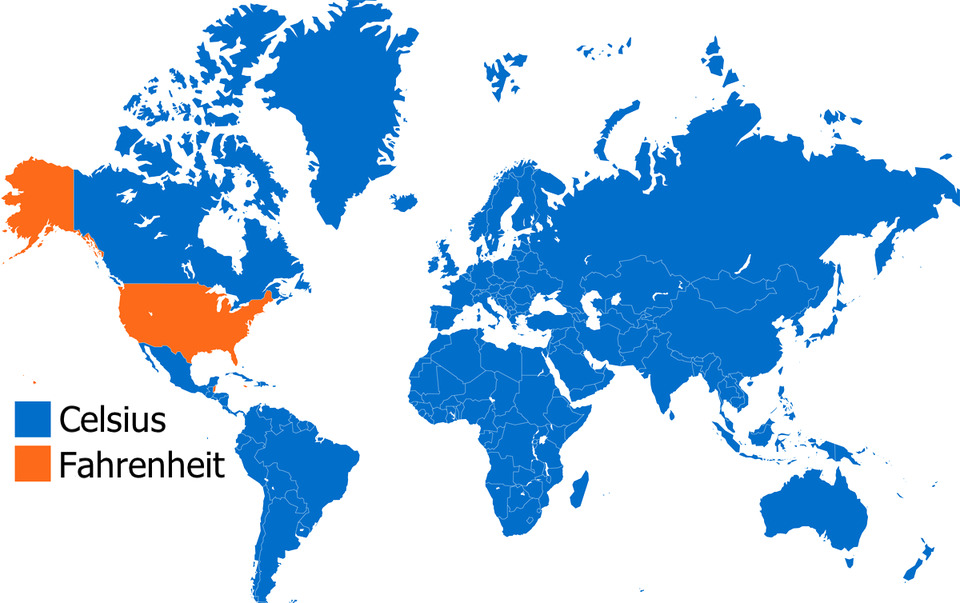
The mapmaker forgot Belize, Palau, the Bahamas and the Cayman Islands which all use Fahrenheit. As for "precision" all that is meant is the smaller difference between individual degrees but most humans can't perceive that small a difference, especially with wind chill, so the point is moot. And, btw- when Fahrenheit invented his thermometer he was trying to compute a scale for measuring body temperature so he chose 100º but his thermometer was off so it when more accurate thermometers came along the 'normal' body temperature had to be back-scaled to 98.6ºF.
Load More Replies...Glad you love it, Aragorn! Do you by any chance have any great maps of Middle Earth to share with us? :)
Load More Replies...I was on this post for almost an hour! I really enjoyed it.
The mapmaker forgot Belize, Palau, the Bahamas and the Cayman Islands which all use Fahrenheit. As for "precision" all that is meant is the smaller difference between individual degrees but most humans can't perceive that small a difference, especially with wind chill, so the point is moot. And, btw- when Fahrenheit invented his thermometer he was trying to compute a scale for measuring body temperature so he chose 100º but his thermometer was off so it when more accurate thermometers came along the 'normal' body temperature had to be back-scaled to 98.6ºF.
Load More Replies...