Guy Searches For Interesting Things On Google Earth And Here’s 30 Of His Best Finds
Geology rocks. Pun very much intended. Now that we've got that out of the way, let' move on to the hardcore things that make up the bedrock of what Bored Panda is all about - beautiful photos that are hot as lava. Please excuse my dad jokes.
A geologist named Will is known for collecting and uploading interesting things he finds on Google Earth. Some of them are very peculiar. Others are breathtakingly gorgeous. But one thing is for certain - all of them are worth seeing. Scroll through our list of Will's amazing discoveries on our beautiful Earth, upvote your favorites, and rock on. Let us know what you think of the geologist's earth views, and after you're done, look through Bored Panda's other list of amazing Google Earth finds.
This post may include affiliate links.

"A fort in Lille, France. I love finding forts while exploring. Star forts are an easy to spot shape. I esp. like finding forts in the middle of cities."

The Fortress is still used by the army, the Headquarter of the quick response force....Take at look at the city of Palmanova in Italy

"This is a private island on the coast of Maine. The bridge has a gate, and the house overlooks a shipping lane in Penobscot Bay. I'd spend all day watching boats, drinking wine, and telling the world to fuck off."
He instead spends all day in front of a computer screen searching for interesting things On Google Earth....

"It looks like an abstract painting. My first thought was a huge archeological excavation site. Turns out that was wrong. These pits are used in a very old fashioned salt extraction operation."
Will goes by the user name geologistsmakethebedrock on Imgur, where he uploads most of his Earth map finds. The geologist from New Orleans told Bored Panda in an earlier interview a little bit about what he does: “I tried to find interesting examples of geologic processes to use in lecture presentations. That’s when I started gathering screenshots of cool stuff and beautiful landscapes for myself. Then I decided to share some images on Imgur because my wife was tired of me making her look at them and listen to my explanations."

"A very sinuous river. This is a good illustration of how oxbow lakes form. In the middle of the image you can see where a meander loop is being actively cut off."

"A real live oasis!. Not all of these tracks are from cars. The smaller ones must be animal."

"Here is a perfect meteor crater. It has a very nice raised rim. I bet if you mapped out the lake bed you would see a central peak too."
"One tip to find interesting geology things is to look for symmetry or patterns in landscapes. Most symmetry is from human activities, but certain geologic processes can create semi-symmetry," the geologist said.
The geologist also wrote on Imgur that he really likes to “peruse Google Earth looking for cool things. My captions either come from basic internet research or my guess about what's happening.”

"I couldn't find anything about this strange place. It's a huge, planned settlement near Namibe, Angola. It seems to have been constructed around 2013-2014. It also appears to be uninhabited due to no vehicles. Does anyone know anything about this place."
Found it. It's the Angolan Social Housing Project, more info here: http://construction.citic/en/content/details_47_2356.html
It's actually just been finished in june this year, so that might be why there's noone around yt in the sat pic.
Load More Replies...There's actually 2 of them in Namibe, one to the east and one to the south just before the airport
Load More Replies...Nothing strange about this place. is just a condominium that at the time was under construction...
I'm From Angola Namibe-5d5...29-png.jpg 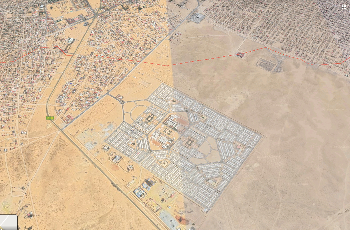
I have actually been there a few years ago - place was still deserted like a ghost town
seems to be this housing project: http://construction.citic/en/content/details_47_2356.html
Images - https://www.google.com/search?q=namibe+angola+social+housing&source=lnms&tbm=isch&sa=X&ved=0ahUKEwjU0M72nIjkAhWjuXEKHb2SBrQQ_AUIEigC&biw=1093&bih=647
This looks good - https://www.angop.ao/angola/en_us/noticias/politica/2018/1/5/Namibe-President-hands-over-keys-new-housing-project-residents,3fc4a15f-20ca-4c32-9f79-f018f938e0fd.html
The Angolan Army may know a lot about this place, which you may prefer not to know.
Isn’t it great when the internet works like it’s supposed to 🤔😃
Send this image to the Embassy of Angola, Windhoek, Namibia, for an explanation. I live in Windhoek, Namibia. Also check out Namibe. It is situated at the confluence of Namibia and Angola, and is famous for the crash of two aircraft, flying on different routes, but crashing into each other over this little God-forsaken place. A German military plane and a US military plane collided in en-route over Namibe. Neither plane's radar seemed to picked up the other's presence. But then, who could possibly think that they would collide with each other over a tiny little place like Namibe. The planes might have both been on auto-pilot with the cockpit crew having a nap! They were flying in space where aircraft are probably never seen or heard. Very strange!
China built it you can read about in on the link from A B C above in comments :)
Load More Replies...It's very weird but i did find a few cars and what looks like buses on the 2 identical diamond shaped roads.
I'd like to know what this is. Military installation? By what country?
"What country" you ask --- it's right there in the caption under the photo.
Load More Replies...

"This is Assamakka, Niger, a community that appears to be fighting a losing battle with the sands.It's easy to see the prevailing wind direction here."
At first, I thought it looked like gemstones, sapphires half showing in the sand. This is tragic.
Most of us use Google Maps and Google Earth to find our way to where we need to go. Because nobody likes getting lost when they’re in a rush. But there will always be people like Will who see an opportunity to use something functional to find things of beauty.
Google Earth first appeared many years ago, way back in 2001; it’s not a kid anymore, because it turned 18 this summer. Yup, Google Earth can now legally vote and get married.

"I recently read the book, "Skeletons on the Zahara." It tells the true story of some US sailors who wrecked on the NW African coast in 1815. It sucked for them. I wanted to see if I could find a ship wreck. I figured a desert coast would preserve metal wrecks well. It didn't take to long to find this one in NW South Africa. It looks like a modern ship, and sure enough it wasn't there in 2003 (the oldest picture available)."
There are quite a few wrecks along that coast and further. I'm a South African so we get news of wrecks. It could very well be something that happened over the last 10-15 years. If you track further north you enter Namibian territory, known as the Skeleton Coast. The number of wreck going back to the 19th century and earlier, can be found along that coastline. It is not an area that is completely accessible to the public. A certain stretch is out of bounds because it is where diamond mining happens. I worked as an architectural consultant in the town of Oranjemund(mouth of the Orange River), which was a closed town up to quite recently. The Orange River is the boundary between South Africa and Namibia, and if you were to travel as the crow flies, from Oranjemund, Namibe would be about 800-850 km north.


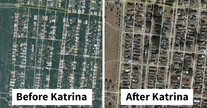
"This is the Lakeview neighborhood.
1 day after Katrina."
What started as a simple project quickly grew in scope to provide ultra-detailed images of our planet. But that’s not all! Did you know that Google’s project to create 3D representations of Earth eventually grew into something spanning the cosmos? That’s right, there are such things as Google Moon and Google Mars. I mean, how amazing is that? We’re hoping that Will decides to look for awesome finds on the Moon and on Mars, too.

"This is some sort of reservoir in Belgium. I've never seen an octagonal pond before. I wonder why they made it that way."
It's a concrete structure, was probably the easiest, cheapest and safest way to make it back in the 70s. It's also not a pond, obviously, but a place to store water. It's a drinking water production facility.

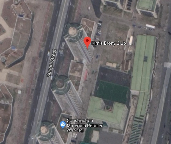
"A park in Pyongyang, North Korea. Someone at Google in going to be in hot water with the glorious leader."

"A lake somewhere on the Tibetan Plateau in summer and winter."
This guy (as a geologist) should spend more time explaining why these areas look the way they do (or at least tell us where they're located).

"Hey, wanna go out?"
"Cant', my...."
We, the Dutch, also have a famous fictive name for a town called: Schubbekutteveen. Used for & in many national jokes.

"Some huge gates protecting Rotterdam from the North Sea waters. What an amazing feat of engineering."
This is the Maeslantkering, a fine piece of Dutch engineering and very necessary as almost half of The Netherlands lies below the water level. The 2 doors are hollow and are flooded with water once in place. The doors actually don't completely close, there is about 80cm left.

"Atolls:
Hot spots not only punch holes in the crust, but the also raise it up and heat it. As the plate moves away, it cools and subsides. The mountains also subside, and also erode. If the mountains are formed in a tropical climate a reef will form around it's edges. If the coral growth can keep up with the relative sea level rise from the subsidence, then the reef will survive while the mountain sinks and eventually disappears below water level. If that happens you will get a circular ring of reef with an open lagoon in the center like the atoll above. At one point there was a volcano in the center of that lagoon. It's a cool example of biology and geology interacting and biology winning, so to speak."

"A volcano poking up out of the South Pacific. I'm not sure if this one is growing or eroding away. Seems like the rich people in boats are having a good time."
This is Molokini Crater of the coast of Maui. I've been here a few times & trust me when I say those are NOT rich people boats. Most of these are snorkeling charter boats because it has beautiful reefs and marine life. During WWII the U.S. military used it for target practice and it shows in the impact craters from shells and bombs dropped on it.


")
"When she wants to go to pound town, but you can only take her to..."

"The Zambezi River downstream of the falls. That's a very unusual path for any river."

"I've never seen this saw-tooth pattern on a beach before."
It is a photo of the zipper keeping the sea and the beach together. Tip of the day: do not unzip it!

"While looking up that lava flow in New Mexico, there were some maps showing some nuclear bomb test sites nearby. This must have something to do with that. I'm fairly sure this is the sight of the first nuclear detonation."
As a species, we sure are proof to "a little knowledge is a dangerous thing", and now Trump is eagerly abetting another nuclear arms race. WHY is he still occupying that post? He is clearly not fit for office.


"A glacier flowing out into a lake. The presence of a connecting stream suggests the 2 parts of the lake are at different levels. The glacier made an ice damn. That's pretty cool.
A river trying to do the same thing in another lake."

"I think this is a coal fired power plant in Egypt. Lookin a little nasty."

"The dark green lines caught my eye because they didn't make sense. My guess was that they were logging roads, but then why are they more vegetated than the surrounding fields?
Going back in time. They are certainly logging roads. I guess different plants grew on the churned up roads, thus the different colors seen in the last image."
Trees actually inhibit ground cover growth around them, especially pine and other evergreen types. when these logging roads were cut into the area, they became overgrown with denser ground cover than the areas they (I assume) replanted. they left the roads for when they return in a few years and reharvest.

"This was a pit of an optical illusion. At first it looked like a pyramid, but the coastline is a bluff, so it must be the inverse of a pyramid. My guess is an abandoned evil villain's mansion."
(a) how about a quarry, or (b) you haven't noticed the last image from Dusk till Dawn where the evil temple is revealed?


"More ships near Tombua, Angola. These might have been intentionally abandoned. They were also not here in the 2003 pics."
Note: this post originally had 151 images. It’s been shortened to the top 30 images based on user votes.


Exactly. Love these kinds of posts...but only when I know the location.
Load More Replies...These are pretty cool photos, but I quit looking after about 40. Please consider cutting these photos down to the top 30, then you can place another post saying something like 'more google earth pics!'
I'm here to make the same suggestion. These are great! But about one hundred more posts than my attention span. We're bored pandas, not tormented pandas.
Load More Replies...What about all the Nazca lines? https://en.m.wikipedia.org/wiki/Nazca_Lines
I learned more from this post than I did from my college intro to geology class, Rocks for Jocks. This was extremely interesting, thank you and I really enjoyed it, thanks!
This list seems incomplete without the potash ponds of Utah. I have been there in real life and can confirm that they actually look like that. 38.484967, -109.681380
I ran across this one recently at 60°44'10.0"S 44°48'03.0"W in the Laurie Island off the coast of Antarctica bird2-5d53...eb843d.jpg 
Exactly. Love these kinds of posts...but only when I know the location.
Load More Replies...These are pretty cool photos, but I quit looking after about 40. Please consider cutting these photos down to the top 30, then you can place another post saying something like 'more google earth pics!'
I'm here to make the same suggestion. These are great! But about one hundred more posts than my attention span. We're bored pandas, not tormented pandas.
Load More Replies...What about all the Nazca lines? https://en.m.wikipedia.org/wiki/Nazca_Lines
I learned more from this post than I did from my college intro to geology class, Rocks for Jocks. This was extremely interesting, thank you and I really enjoyed it, thanks!
This list seems incomplete without the potash ponds of Utah. I have been there in real life and can confirm that they actually look like that. 38.484967, -109.681380
I ran across this one recently at 60°44'10.0"S 44°48'03.0"W in the Laurie Island off the coast of Antarctica bird2-5d53...eb843d.jpg
