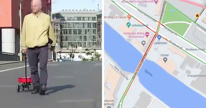
One day in Berlin, Google Maps showed the red line denoting bumper-to-bumper traffic on several ordinarily calm streets, even though there was no special event taking place. Or anything happening on those streets, actually. The culprit: one man slowly walking around the city pulling a red wagon.
Berlin artist Simon Weckert rented 99 Android smartphones, installed 99 sim cards in them and filled a wagon with them, all powered on and running Google Maps. He then took to the streets of Berlin with them at a time when traffic was sparse. The object of the experiment, which he conducted last summer, but just published yesterday for the 15th anniversary of Google Maps, was to show how much we rely on the app’s traffic technology despite its limitations. It also answers some questions we’ve probably all had about how Google Maps actually works.
Artist Simon Weckert walked around Berlin with 99 phones in a wagon

Image credits: Simon Weckert

Image credits: Simon Weckert

Image credits: Simon Weckert

Image credits: Simon Weckert
The way Google Maps estimates traffic is by assessing the density of phones that enable the app to access their location, confirmed a Google spokesperson. Therefore, to the app’s technology, the only explanation for Weckert’s 99 phones in a condensed space was a dense traffic jam. The spokesperson also said, somewhat creepily, that Weckert’s experiment helps Google figure out where its geolocation needs to improve. It can distinguish between the motions of a car and a motorcycle, apparently, but recognizing movement in a wagon is still beyond it.

Image credits: Simon Weckert

Image credits: Simon Weckert

Image credits: Simon Weckert

Image credits: Simon Weckert

Image credits: Simon Weckert

Image credits: Simon Weckert

Image credits: Simon Weckert

Image credits: Simon Weckert
If you’re wondering why a bus full of people with smartphones doesn’t automatically show up as a traffic jam, a bus is very easy to recognize via geolocation, as such a cluster of users follows a predictable path and stops in predictable places. Maybe Weckert’s next experiment should be trying to fool Google Maps into thinking he’s a bus.
A video of the experiment shows how quiet the streets actually were during the “traffic jam”
Image credits: Simon Weckert
The question on everyone’s minds is why? Weckert wanted to show how we rely on data to predict reality for us so we can plan our actions around it, trusting it as an objective display of reality, even though the technology used to interpret data can err or be misled, potentially forming an inaccurate model. Commenters are already coming up with ideas for gaming the system based on his experiment, while others think it worked a little too well and could have dangerous consequences.
Not everyone sees the value of the experiment, but it gave some people ideas


I did not know google estimates traffic by assessing number of phones being used
That's how they can say how long people usually stay at a certain place like a restaurant or when it's the best time to go there.
Load More Replies...I find this very amusing. This guy is proving that Google now is so powerfull that it can control traffic flows in any given city. Yes, the friendly search engine has turned into your worst nightmare and a lot of people keep supporting it. I also think that it's hilarious that BP is blurring his face, while the artist doesn't hide his name nor where he is and he's clearly recognisable in the video.
Imagine hearing all those “You have now reached your destination” or “Turn left in 300 feet”.
Recalculating being said in that tone of voice that isn't meant to sound aggravated but is most definitely pissed at you for taking the wrong turn in a not so subtle and almost aggressive sounding way lol
Load More Replies...Lol sounds like something my dad would do XD Screenshot...fd-png.jpg 
I didn't understand this post, are you able to explain? What is waze, is it a map service where you can tag items for public view, ie plant a cop? That's my best guess anyhow ^-^
Load More Replies...There is a business to be created here. Pay me and I will walk my cart up and down your competitors street. Anyone know where I can 100 cheap phones?
That was pointless, needless to say, but also epic. I mean, it would be bad if it caused inconvenience, obviously, but still - it's quite creative and shows a lot of ingenuity. Now, I want to know where he got so many phones.
lol i would totally do this. the guy's got a pretty good sense of humor
Lame. Technological advancement isn't a bad thing 99% of the time. People relying on data isn't new, either.
who has money to have brand new like 99phones? o.O who walks with 99phones in streets without being robbed?
He rented them, it said in the article. I've not heard of renting phones perhaps it's a service normally for tourists and others who need a phone short term
Load More Replies...How does this even work? How can Google differentiate between a cellphone in a car or a person whit a cellphone?
Google counts the phones and the movement..... when number increases and/or the movement slows, google indicates a traffic jam
Load More Replies...What an idiot. First thing I think of is emergency crews trying to get places. Ambulances are driving around town all day long
What if everyone on a bus opens Google maps on their smart phones? What if all the people on all the buses in the world open Google maps on their smart phones?
You actually do not need to open google maps. If you have given google permission to use your location at any time then they are receiving those statistics.
Load More Replies...@WilvanderHeijden: This: "This guy is proving that Google now is so powerful that it can control traffic flows in any given city." All the ultra big tech companies need to be broken up. Our laws need to change. When they were written, there was no possibility for anyone, not even the worst secret service of the very worst totalitarian states, to gather as much information about any person as the big tech companies are now harvesting from whatever we do online. This is what he is pointing out, that information technology is not foolproof, that it is always aware of where you are, and that it also controls our actions in various ways. We have ended up with billionaires buying data to influence unsuspecting people to vote the way a select few want them to. Democracy as we knew it is being reduced to a sham!
I agree with the above statement, what if someone on the street had an emergency and first responders were delayed by the perception of a major traffic jam. Pointing out a flaw in the system that has no real-world application is a form of trolling.
First responders would not use Google maps to find out how to get where they are going.
Load More Replies...I did not know google estimates traffic by assessing number of phones being used
That's how they can say how long people usually stay at a certain place like a restaurant or when it's the best time to go there.
Load More Replies...I find this very amusing. This guy is proving that Google now is so powerfull that it can control traffic flows in any given city. Yes, the friendly search engine has turned into your worst nightmare and a lot of people keep supporting it. I also think that it's hilarious that BP is blurring his face, while the artist doesn't hide his name nor where he is and he's clearly recognisable in the video.
Imagine hearing all those “You have now reached your destination” or “Turn left in 300 feet”.
Recalculating being said in that tone of voice that isn't meant to sound aggravated but is most definitely pissed at you for taking the wrong turn in a not so subtle and almost aggressive sounding way lol
Load More Replies...Lol sounds like something my dad would do XD Screenshot...fd-png.jpg
I didn't understand this post, are you able to explain? What is waze, is it a map service where you can tag items for public view, ie plant a cop? That's my best guess anyhow ^-^
Load More Replies...There is a business to be created here. Pay me and I will walk my cart up and down your competitors street. Anyone know where I can 100 cheap phones?
That was pointless, needless to say, but also epic. I mean, it would be bad if it caused inconvenience, obviously, but still - it's quite creative and shows a lot of ingenuity. Now, I want to know where he got so many phones.
lol i would totally do this. the guy's got a pretty good sense of humor
Lame. Technological advancement isn't a bad thing 99% of the time. People relying on data isn't new, either.
who has money to have brand new like 99phones? o.O who walks with 99phones in streets without being robbed?
He rented them, it said in the article. I've not heard of renting phones perhaps it's a service normally for tourists and others who need a phone short term
Load More Replies...How does this even work? How can Google differentiate between a cellphone in a car or a person whit a cellphone?
Google counts the phones and the movement..... when number increases and/or the movement slows, google indicates a traffic jam
Load More Replies...What an idiot. First thing I think of is emergency crews trying to get places. Ambulances are driving around town all day long
What if everyone on a bus opens Google maps on their smart phones? What if all the people on all the buses in the world open Google maps on their smart phones?
You actually do not need to open google maps. If you have given google permission to use your location at any time then they are receiving those statistics.
Load More Replies...@WilvanderHeijden: This: "This guy is proving that Google now is so powerful that it can control traffic flows in any given city." All the ultra big tech companies need to be broken up. Our laws need to change. When they were written, there was no possibility for anyone, not even the worst secret service of the very worst totalitarian states, to gather as much information about any person as the big tech companies are now harvesting from whatever we do online. This is what he is pointing out, that information technology is not foolproof, that it is always aware of where you are, and that it also controls our actions in various ways. We have ended up with billionaires buying data to influence unsuspecting people to vote the way a select few want them to. Democracy as we knew it is being reduced to a sham!
I agree with the above statement, what if someone on the street had an emergency and first responders were delayed by the perception of a major traffic jam. Pointing out a flaw in the system that has no real-world application is a form of trolling.
First responders would not use Google maps to find out how to get where they are going.
Load More Replies...
151
47